|
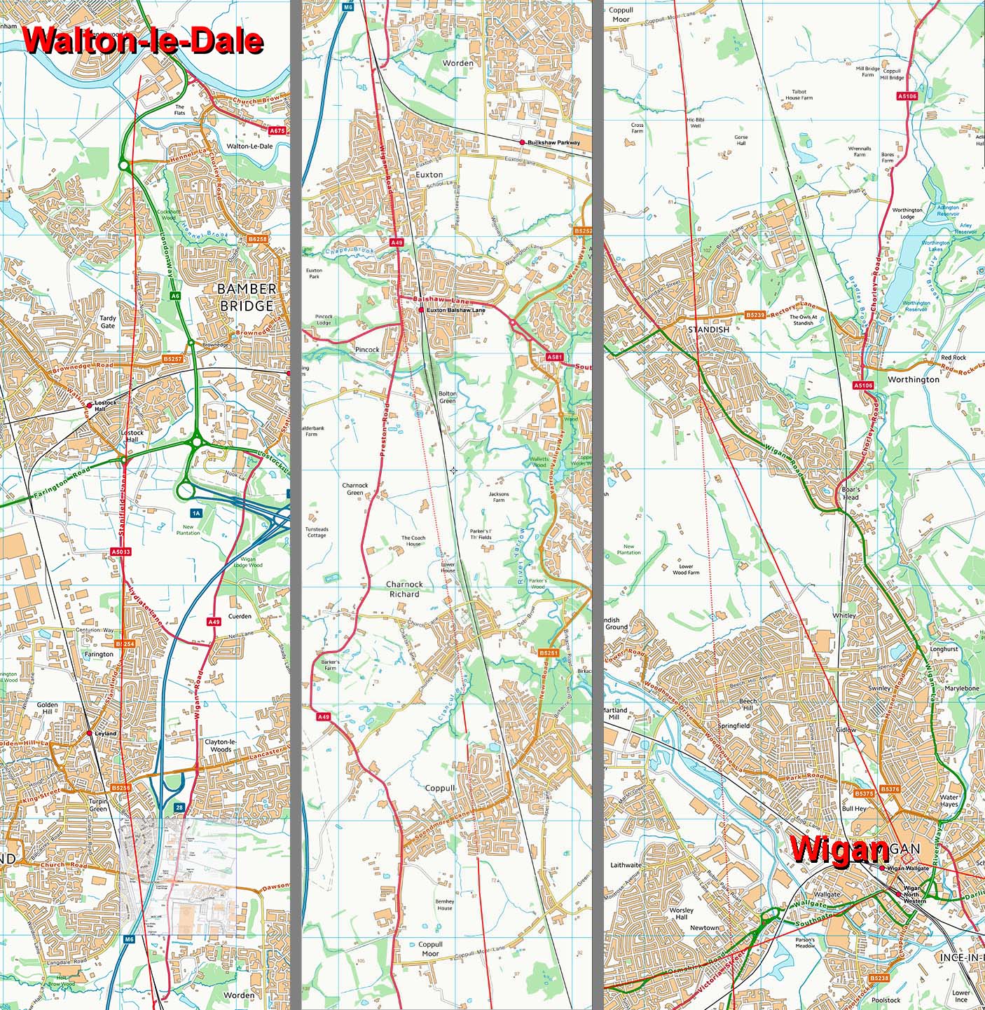
The Roman Road from Wigan to Walton-le-DaleMargary Number: 70cDistance: 14.75 milesThis road is never far from the A49 which is clearly derived from it although with many diversions over the centuries. The Roman road from Wigan fort seems to initially head for Prospect Hill, Standish. Here it would regain the same alignment as the Roman road south of Wigan. This is a fairly common arrangement and the road layout at Ribchester is very similar. From Standish the route heads pretty directly for Leyland before a slight turn for Walton-le-Dale. Note the route of this road was "officially" assumed for many years to have gone via Meanygate at Lostock Hall, i.e. about one mile further east than that showjn here. The route via Leyland-Stanifield Lane-Todd Lane was first posulated on these pages over 20 years ago and with the 2018 excavation at Stanifield Lane this has been confirmed as correct. |
Historic County: Lancashire Current Counties: Greater Manchester & Lancashire HER: Greater Manchester & Lancashire
|
|
|
|
|
|
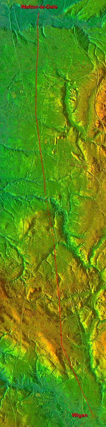
Lidar Image - Full Route The alignment does make a lot of sense. A straight route would have ended up in a couple of valleys so initially heading west-north-west from Wigan to Standish had much to recommend it. The route comprised 3 alignments; Wigan to Standish, Standish to St Ambrose Church (Leyland) and St Ambrose to Walton-le-Dale.
|
Click for larger view
|
 |
Lidar Image - Roman Roads of Wigan The setting out alignment of the north-south road seems to have been on Prospect Hill, Standish. The road from Wilderspool appears directed at this high point. The road to Walton-le-Dale then heads from Wigan to rejoin the main alignment. Only then does it turn for Walton-le-Dale.
|
Click for larger view |
 |
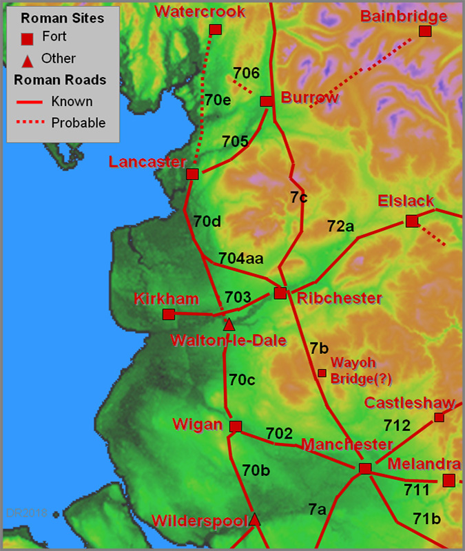
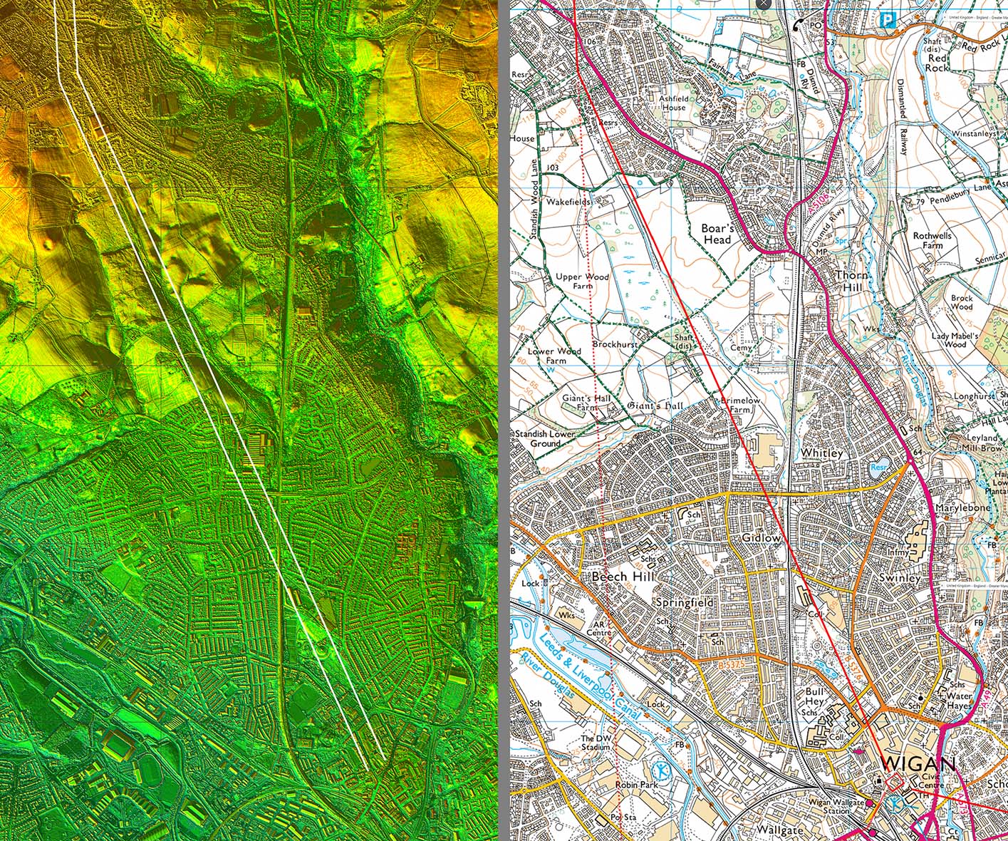
Wigan Map - Roman Roads I think at long last we may may getting an accurate map of the Roman roads of Wigan. There is now a logic as to why the road from Wilderspool does not take a short cut into the fort at Wigan - it joins the Burscough road for a common route into the town. The Manchester road we are reliant on Watkin but he does seem to have generally got the route correct. The road to Walton-le-Dale, thanks to Wigan AS and lidar series 2 data, is now also pretty secure.
|
Click for larger view |
 |
Wigan to Walton-le-Dale - Detail Route Map The alignment from south of Wigan is shown dashed and is an extension of the southern approach to Wigan. This is purely a Roman setting-out line and there is no evidence for a road bypassing Wigan on this line.
|
Click for larger view
|
 |
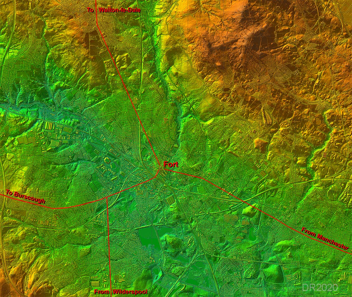
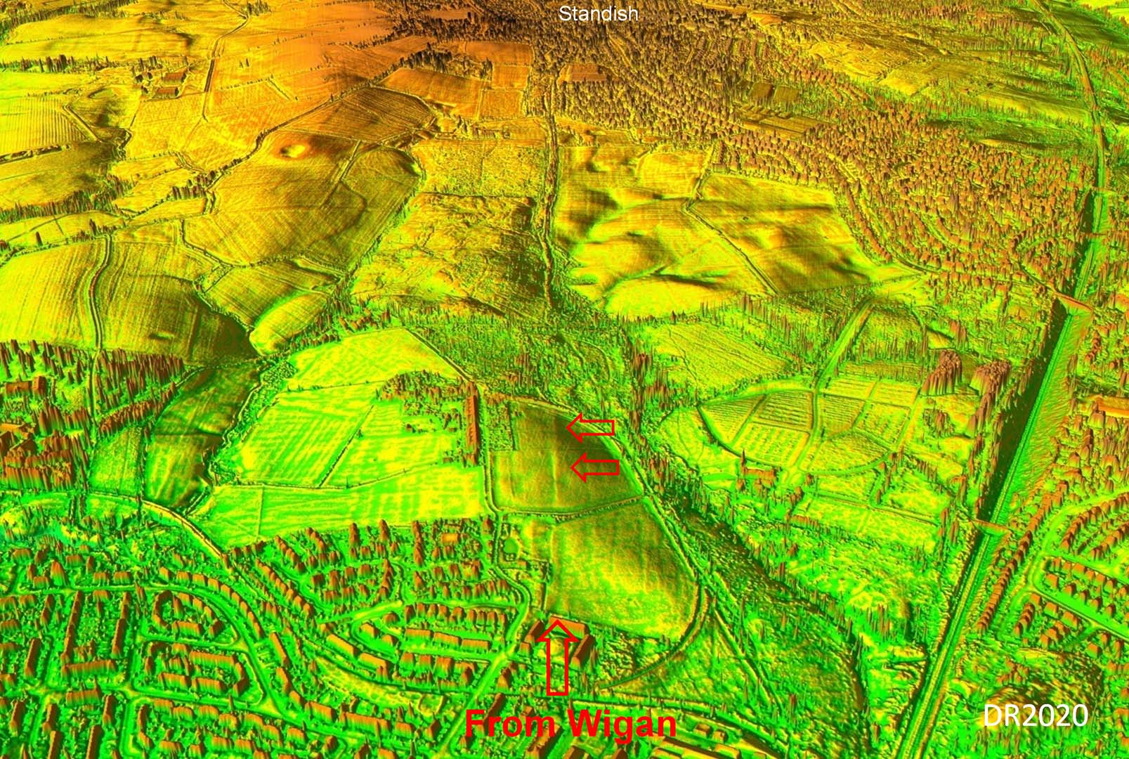
Lidar & Route Map - Wigan to Standish The Roman site at Wigan is now thought to have been a fort (ref: Miller & Aldridge). It was located somewhere near the top of the hill in central Wigan. Barrack blocks (inside the fort) and a bath house (outside the fort) have been found in excavations and go some way to positioning the fort approximately. What is shown is therefore one of the possible solutions but it would fit with the alignments of the Roman roads that converge on Wigan The availability of series 2 lidar (see below) now confirms the alignment to Standish with reasonably high confidence.
|
Click for larger view
|
 |
3D Lidar view from Wigan towards Standish The first alignment of the road from the fort in Wigan was on Prospect Hill at Standish, where it would rejoin the main north-south alignment from south of Wigan. Despite the extensive mining activities around here some of the road has survived. Wigan Archaeological Society have excavated at Brimlow Farm for several years now (see below). Beyond where they excavated the road appears to have survived in the next field north. It is then overlaid by an abandoned mineral railway to Prospect Pits (mine).
|
Click for larger view
|
 |
Road excavation at Brimlow Farm Wigan Archaeological Society have found the link road from Wigan to Standish near Brimelow Farm heading towards Prospect Hill, almost certainly to return to the main north-south alignment. Subsequent exacavations including those in 2018 have confirmed the road and its probable width of 10 metres. It was constructed of what appears to be river sorced pebbles/stones. As there is no big river in the vicinity it would mean they were transported a considerable distance. Image courtesy of Bill Aldridge, WAS. |
Click for larger view |
 |
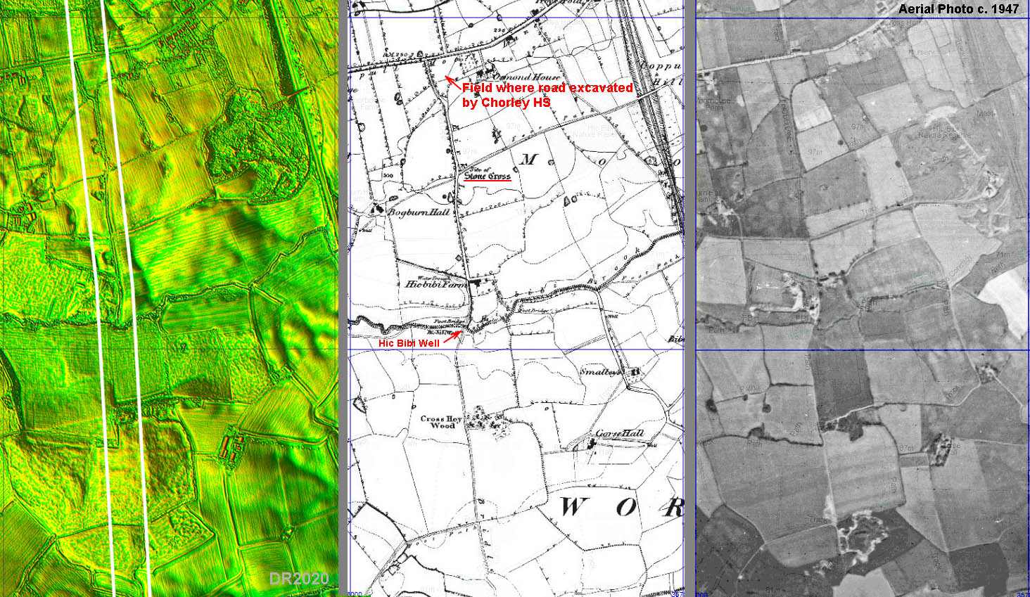
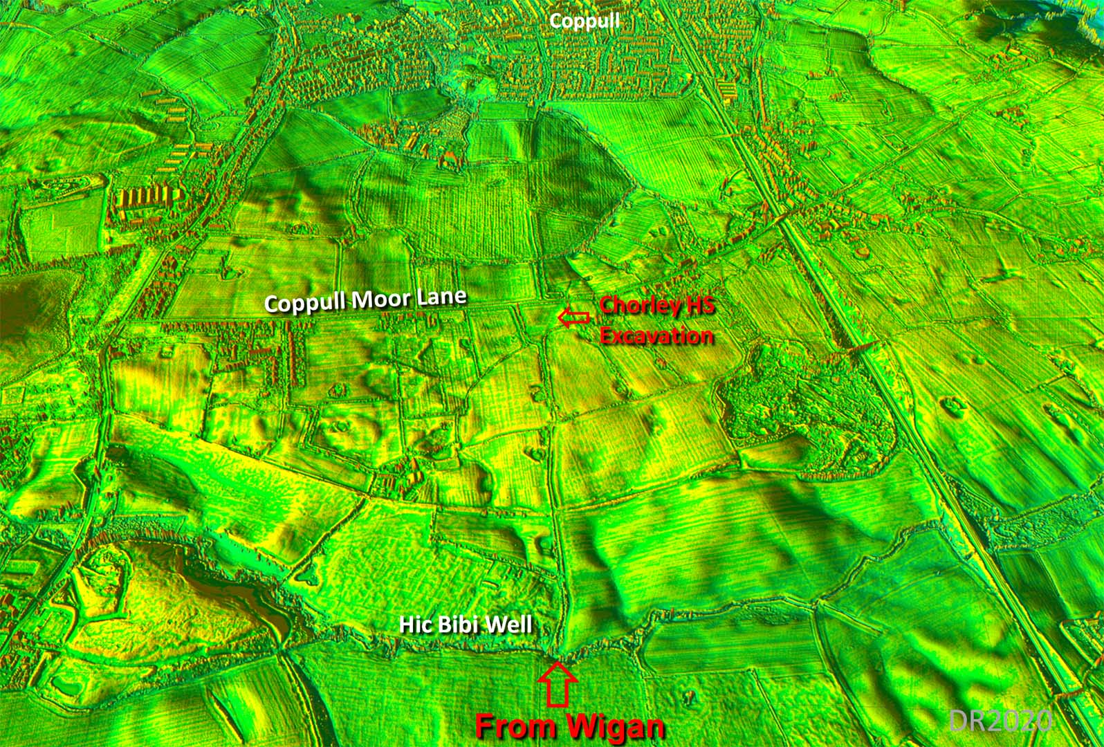
Hic Bibi Lane - OS First Edition Map & Aerial Photograph c.1947 Having regained the north-south alignment in the vicinity of Prospect Hill, the road would have turned to the north. North of Standish, Hic Bibi Lane is generally taken to be the line and would fit with that turn at Prospect Hill. Unfortunately the Hic Bibi area has been much devastated by mining. Note the stone cross indicating that is an ancient route. The Hic Bibi Well is supposedly where Oliver Cromwell drank. Perhaps just folklore but again it indicates that this was the old road line here. The field where Chorley Historical Society carried out two excavations is shown at the top - see also below. |
Click for larger view |
 |
3D Lidar Image - Hic Bibi to Coppull I would suspect the little chicane at Hic Bibi probably derives from the Roman line. That field where Chorley HS found the road (see below) shows nothing. If you drive along Coppull Moor Lane then the modern road does actually hump over the Roman agger. |
Click for larger view |
 |
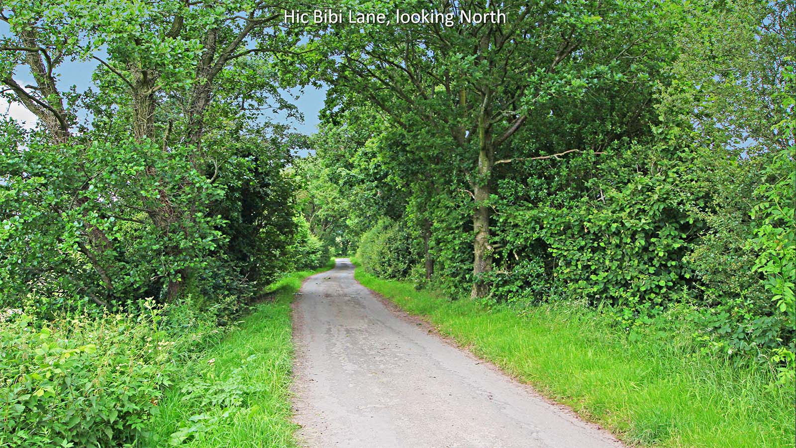
Hic Bibi Lane This is probably the best surviving stretch of the road between Wigan and Walton-le-Dale with pronounced agger and roadside ditches. The excavation field (see below) is at the end of the lane in this view - the lane swings off to the left there.. Image: DR |
Click for larger view |
 |
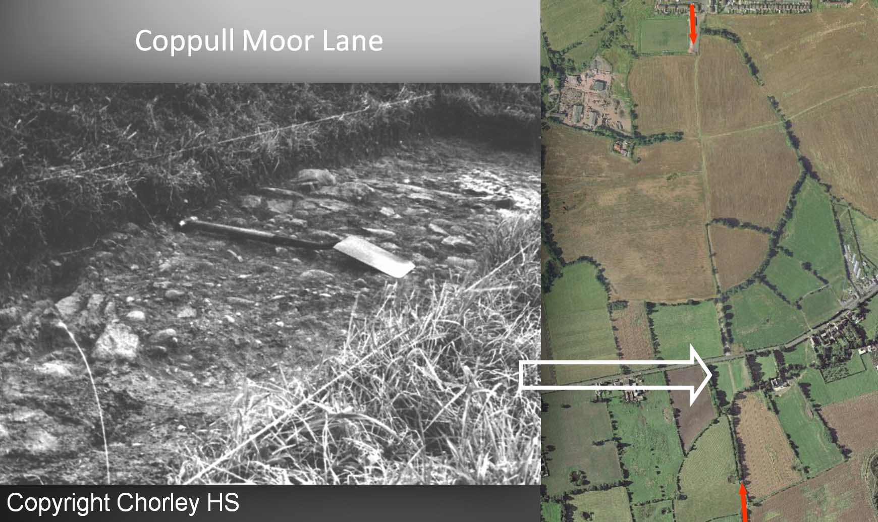
Coppull Moor Lane Excavation Chorley and District Historical and Archaeological Society carried out excavations in 1959 or 1963? and 1985 in the field just south of where Hic Bibi Lane reaches Coppull Moor Lane. The photo below is believed to be of the road at the north end of the field just south of Coppull Moor Lane. A geophysical survey was carried out by Archaeological Services WYAS (Leeds) in 2011 on the same field where Chorley excavated the road but failed to detect the road. The recent series 2 Lidar shows no trace in this field whicg probably explains why the geophys was unsuccessful. Image copyright Chorley and District Historical and Archaeological Society |
Click for larger view |
 |
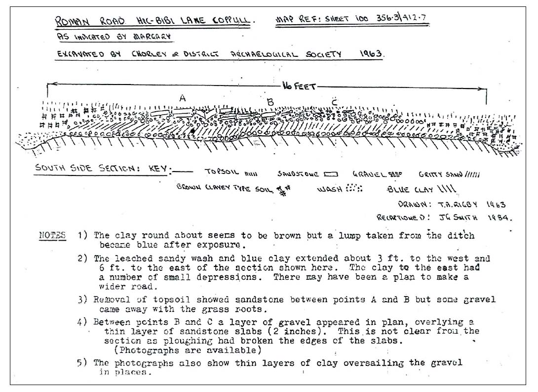
Coppull Moor Lane Excavation - Cross Section Chorley and District Historical and Archaeological Society's excavation (dated 1963) has a16 feet wide agger with ditches. Perhaps it was 1963 not 1959? This cross section is believed to be at the south end of the field but recorded details are somewhat vague on this. Section copyright Chorley and District Historical and Archaeological Society |
Click for larger view |
 |
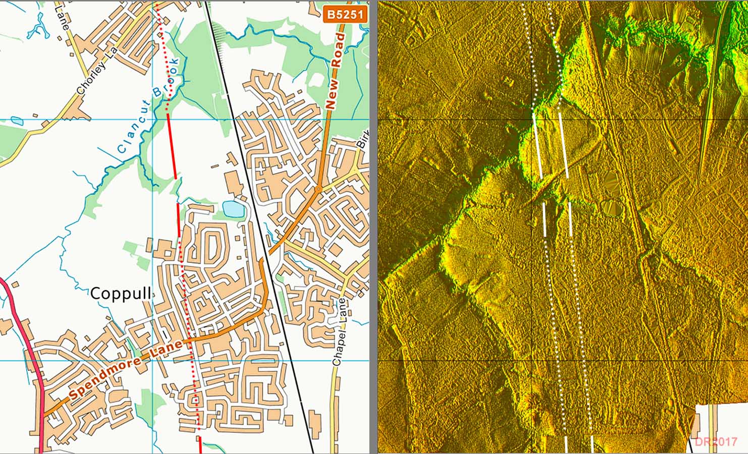
Route Map & Lidar Image - Row High Wood Coppull Projecting the Hic Bibi alignment to the north of Coppull then Lidar has revealed probable traces across Row High Wood approaching Clancut Brook and perhaps a dogleg to cross the valley. This is a critical piece of evidence in extending the Hic Bibi alignment northwards. Beyond here for the next 3 kilometres clues become scarce but as this last alignment appears to be aligned with the A49 at Euxton it probably safe to assume it did continue on a straight course. There is no obstacle or difficult ground to warrant a deviation.
|
Click for larger view |
 |
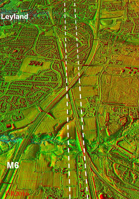
3D Lidar View - looking north from Pack Saddle Bridge The Roman road therefore and the A49 probably coincide passing Euxton Park and Hall. Further on, where the A49 turns sharply to go under Pack Saddle Bridge, new Lidar evidence indicates that it carried straight on (see Lidar image right). There are signs both before and after the railway but the clearest is just beyond the M6 motorway.
|
Click for larger view |
 |
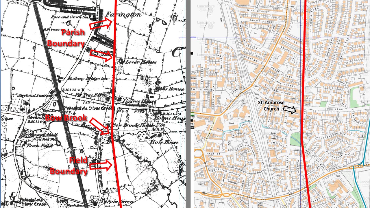
Leyland-Farington - OS First Edition Map & Modern Map All built over here now but a field boundary near Turpin Green and a straight old parish boundary heading to Farington marks the Roman road north of Fir Tree Farm on Moss Lane. Note the stone cross site too. Fir Tree Farm has long gone and our road probably goes through the end of St. Ambrose Church, which was built on the site of the cross. The Parish boundary has survived as the back boundary of the houses on the west side of St. Annes Road - see below.
|
Click for larger view |
 |
Bow Brook & St. Ambrose Church, Leyland The road seems to have made its last turn for Walton-le-Dale just beyond Bow Brook at St. Ambrose Church (tower visible). No trace visible here today due to landscaping but the course of the road must have been close to that shown. The bow in Bow Brook was removed and it now runs in a straight course to the left of this view. Image: DR
|
Click for larger view |
 |
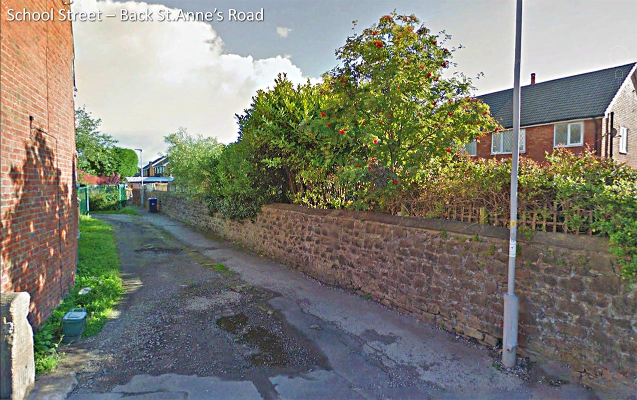
School Street & Back St. Annes Road, Farington At the bottom of School Street and the back of St. Annes Road then there is still a right of way (footpath) along the line of the road. This is the parish boundary between Farington and Leyland. Image: Google Streetview |
Click for larger view |
 |
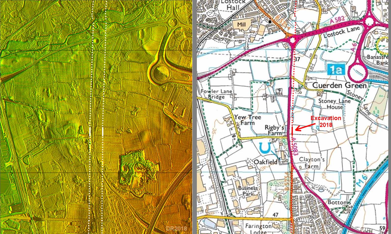
Stanifield Lane - Rescue Excavation May 2018 This was the absolute confirmation that the Leyland-Stanifield Lane-Todd Lane was the correct route although it was pretty obvious well before this. Stanifield was always a clue - meaning of course stoney field and how true this turned out to be! This rescue excavation at Cuerden Green, to the east of Stanifield Lane, was a result of the Lancashire Central development. Part way through the excavation the development collapsed due to Ikea pulling out and an application for an extension withdrawn. However, there was enough time to prove the road line - 25 metres to the east of Stanifield Lane. This lines in well with Stanifield Lane to the south and Todd Lane to the north.
|
Click for larger view |
 |
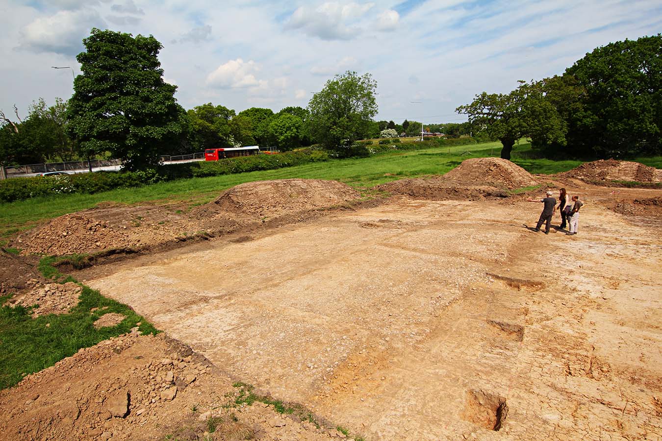
Stanifield Lane - Rescue Excavation 2018 - looking North The road consisted of rammed gravel/pebbles but the big surprise was its width - up to 11 metres at its widest point. A ditch on its east side veered off the road line - see right - which was somewhat puzzling. To the right of the 3 people in the picture was a roundhouse. This was very clear in the clay with an entrance facing the road. This would appear unlikely to be just a coincidence and perhaps represents a local entrepreneur setting up business alongside the road. Image: DR
|
Click for larger view |
 |
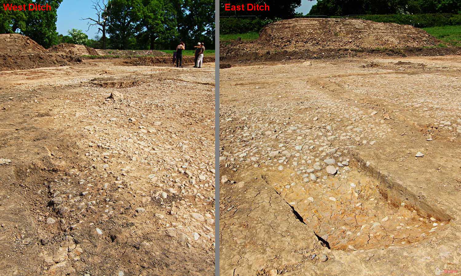
Stanifield Lane - Rescue Excavation 2018 The east ditch was evident but the west ditch appeared to have been disturbed by later activity and was not as obvious. The cambered road edges were both clear however. It was planned to cut a cross section through the road but the collapse of the development brought a hasty end to the excavation which was back-filled before this could take place. The foundation makeup of the road is therefore unknown. Image: DR
|
Click for larger view |
 |
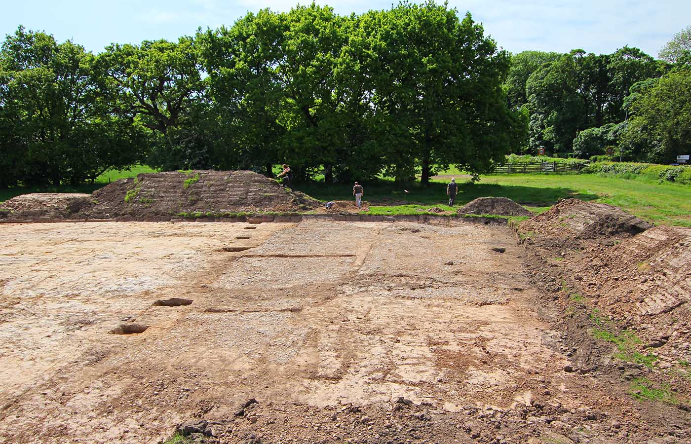
Stanifield Lane - Rescue Excavation 2018 - looking South This was as far the excavation went before it was back-filled. The road was in remarkably good condition. The straight raised features over the road were unexcavated strips for access without walking on the surface. As the clay ground was baked hard during a dry spell this was perhaps unnecessary. The excavation was carried out by Oxford Archaeology (North) based at Salford University under the direction of Ian Miller. Image: DR
|
Click for larger view |
 |
Todd Lane - OS First Edition Map & Aerial Photo c.1947 Stanifield Lane alignment fits perfectly with Todd Lane. The latter wanders around today but old field field boundaries across two of the bends probably mark the original straight line. Todd Lane also has old crosses indicating some age. The alignment also fits well with that of the road found in the Walton-le-Dale excavations.
|
Click for larger view |
 |
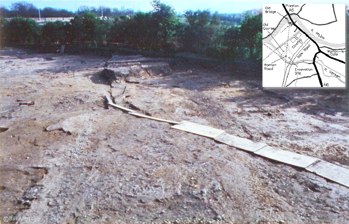
Walton-le-Dale Excavation, 1996 This was the critical excavation that showed the accepted line (via Meanygate) was incorrect and the actual line must lie further west. The excavation was in advance the the Capitol Centre Development and exposed the road. It had been re-surfaced many times in its (Roman0 existence. It can be seen pointing south in the direction of the new road - visible over the hedge. It was this excavation that prompted the search for a more westerly route and this was first suggested on the forerunner of these web pages 20 years ago. The line suggested turned out to be correct - see next image. Image courtesy of Bill Aldridge, Wigan AS. For Wigan Archaeology's newsletter covering the excavations - follow link. Finds from Walton-le-Dale are on display in South Ribble Museum and Exhibition Centre - recommended. |
Click for larger view |
 |
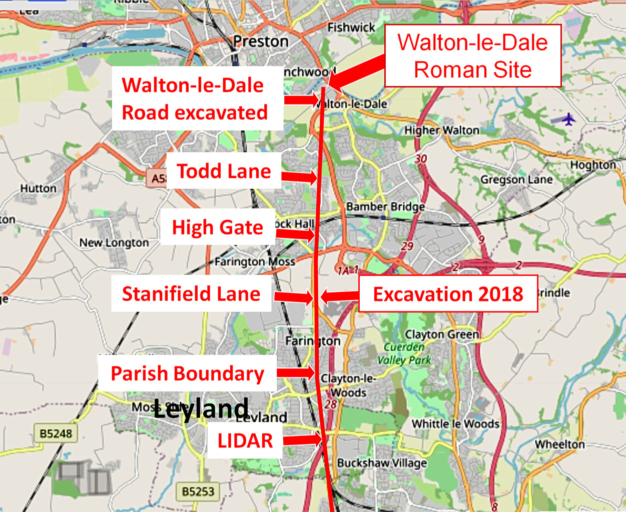
Clues approaching Walton-le-Dale Taken altogether then then there is sufficient proof to confident that this is indeed the course of the road heading for the Walton-le-Dale site. The High Gate name appears on the 1931 OS map but did someone know something? The Cuerden Green Excavation alongside Stanifield Lane in 2018 was the final proof - if proof were still needed. The Walton-le-Dale Roman site is still very much a puzzle despite those rescue excavations in advance of the Capital Centre development. Clearly an important Roman site but no sign of an actual fort. It would be a logical location for one but the evidence points to a military supply base and workshops alongside a probable river port. This is likely about as far upstream as supply boats could practicably reach for Ribchester.
|
Click for larger view |
 |
|
|
|
Last update: July 2020 |
© David Ratledge |