|
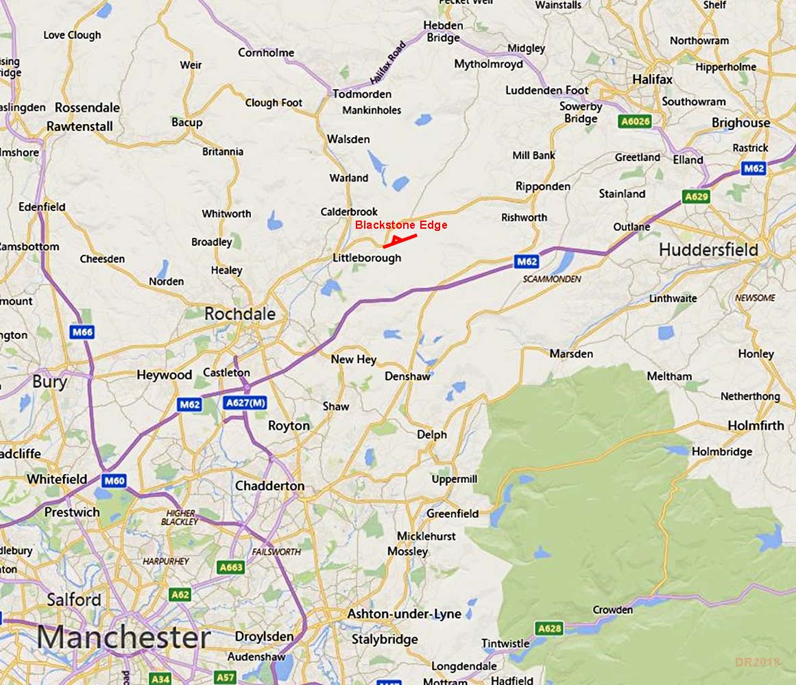
The Supposed Roman Road over Blackstone EdgeMargary Number: 720aDistance: NAProbably the most famous Roman(?) road in the old Lancashire county, the Blackstone Edge Road.This short section with its puzzling centre channel has been the subject of intense debate as to its origin. Championed in the 1920s by the legendary Professor Ian Richmond as Roman then who would dare to question this? It was a local amateur,James Maxim , who had the audacity to challenge the professional wisdom. His book, A Lancashire Lion (1965), examined the evidence and found a medieval pack-horse track passing UNDER part of this road and therefore older than it! He always referred to this road as the Blackstone Edge Long Causeway and it now appears his contention was almost certainly correct with this road being a very early Turnpike dating to 1735 - a little late to be Roman. |
Historic Counties: Lancashire & West Riding of Yorkshire Current Counties: Greater Manchester & West Yorkshire HER: Greater Manchester & West Yorkshire
|
|
|
|
|
|
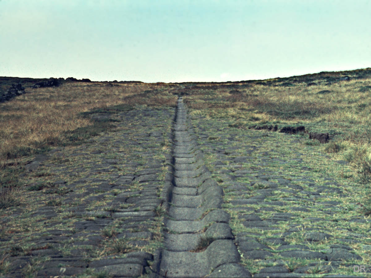
Blackstone Edge Long Causeway (the Supposed Roman Road) In 1923, Ian Richmond excavated a section across the road finding it was constructed of single blocks set on top of the natural peat. Down the centre of the road was the curious recessed channel (see right). He went on in 1926 to put forward evidence for a possible Roman road on a line from Manchester to Blackstone Edge and argued that the paved road here was of Roman construction. It must be said Richmond wasn't the first to suggest it as Roman but his opinion carried huge weight. However, its unique untypical Roman construction always cast doubt on its true origin. It also starts very abruptly, again hardly a Roman characteristic. A more recent article in the Greater Manchester Archaeological Unit's Journal (Pearson et al., 1984/5) records the historical evidence - with one notable exception - for this road. Although taking a neutral stance, one sentence did tend to suggest it was of more modern construction than Roman. That notable exception they didn't refer to - it was the book by James Maxim - see below. Regarding the puzzling central groove - well many suggestions but the most often quoted is that is was worn by the brake poles of descending vehicles. As we shall see there is an alternative solution. Image: DR, taken in the early 1970s when it was still in Lancashire. |
Click for larger view
|
 |
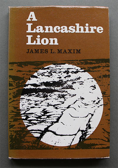
A Lancashire Lion by James L Maxim (1965) A book by a local (to the road) who spent his lifetime studying the site and the historical records of the various roads over the edge. But he was an amateur so largely shunned by profession researchers. After all Richmond himself had said it was Roman. It was actually published after his death and is sometimes available in local bookshops. It is well worth searching out. Maxim always referred to the Blackstone Edge "Roman" road as the Blackstone Edge Long Causeway. He points out that prior to 1735 the road was always described as "narrow" and "ruinous". Hardly a fit description for this road with it being paved and around 16 feet wide! The significance of the 1735 date is that is when the first turnpike road over the edge was built (1734 Act). Note: although an amateur, Maxim was highly qualified and was a frequent lecturer at Rochdale Art Gallery on local history. |
Click for larger view |
 |
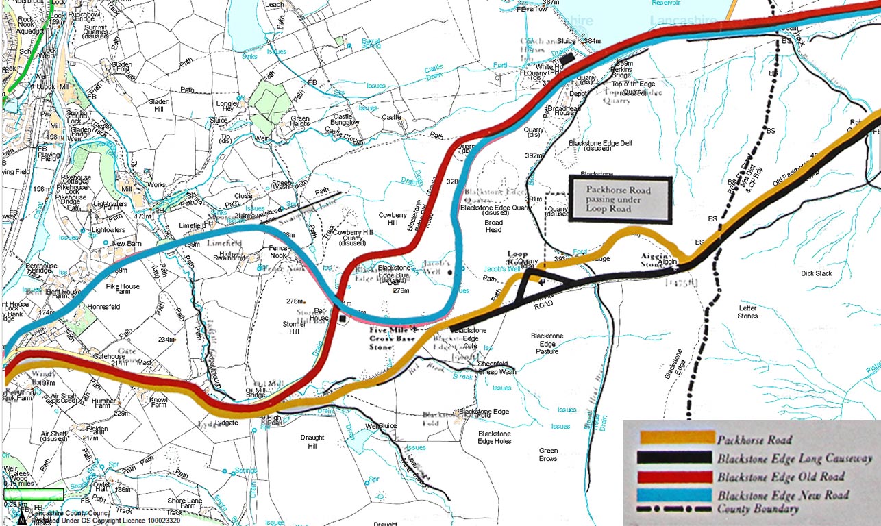
Blackstone Edge - Modern map with Maxim's roads A composite image with Maxim's routes for the various roads over the edge overlaid onto a modern map. The routes are shown in the key in chronological order. The medieval pack-horse track passes under the supposed Roman Road - or at least its zig-zag loop road. There is little doubt the loop road and the long causeway are contemporary. Even if the loop was built much later it really doesn't change the logic. Why would anyone build a medieval pack-horse track alongside a 16 foot wide paved road? The Long Causeway has to be later than the pack-horse track. The 1734 Turnpike Act described the existing road as "narrow, deep, ruinous and impassable for wagons" and went on to add the "existing road could not be mended". Again not really suggestive of an already existing 16 feet wide paved causeway. Perhaps the most intriguing statement in the act was the adopting of an "extraordinary mode of improvement". Dates: Blackstone Edge first turnpike - 1735 |
Click for larger view |
 |
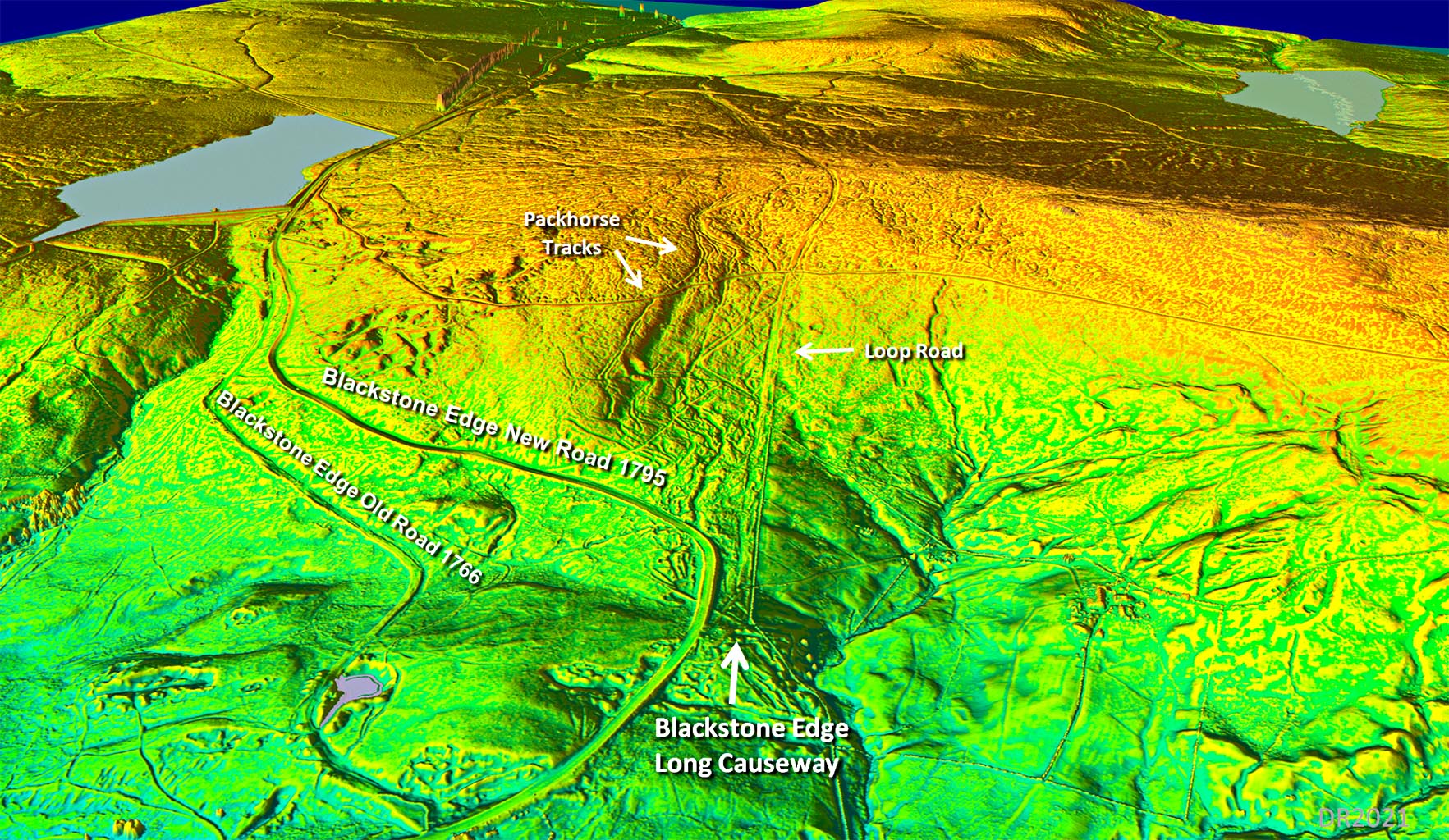
Oblique Lidar 3D View The location of the various turnpike roads depicted on the above map are clearly visible in this Lidar view There are 3 roads and 3 turnpike acts so it seems pretty obvious which is which and that the Blackstone Edge Long Causeway (the supposed Roman road) must therefore be the 1735 Turnpike. The various Pack Horse routes - there were clearly several and these were described as "narrow" and "ruinous" . If there was a paved Roman road there why all the pack horse tracks. It makes no sense. Also clear is the sudden start of the Long Causeways - connected to nothing Roman. |
Click for larger view |
 |
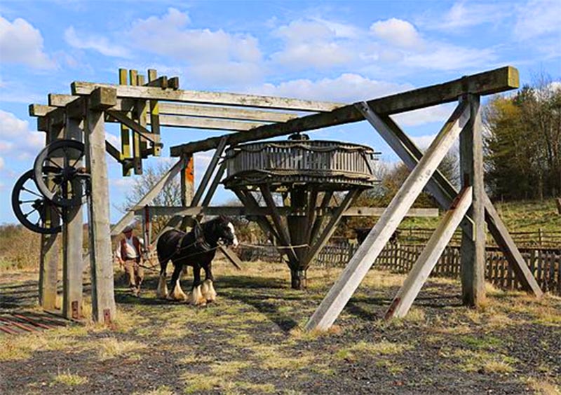
Horse Gin at Beamish Museum That extraordinary mode of improvement? Could this have been a horse gin winding engine for hauling wagons up the 1 in 5 slope? Some evidence for this is a circular foundation block at the top. This would explain the central groove. This technology had been common in the mining industry for many years (centuries) before and after the turnpike date. In the picture the horizontal drum worked by the horse would have carried the hauling cables. Beamish Image: licensed under the Creative Commons Attribution |
Click for larger view |
 |
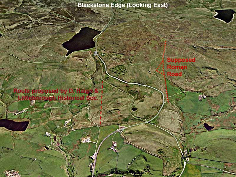
Swaindrod Lane - alternative route? However, the options perhaps don't end there. Following excavations by Littleborough Historical Society, an alternative route over the Edge was suggested. This is aligned on Swaindrod Lane and they found some evidence for an agger and ditches. This route was previously suggested by Donald Haigh in the 1980s, who found two lengths of agger totaling 250 metres (Greater Manchester Archaeological Journal Vol 3). Also on the Littleborough HS site is an aerial photo which they suggest looks like traces of a possible Roman fort at Cloise Farm, just off Swaindrod Lane. 2021 Update - the release of Series 2 Lidar data for this area shows that the Swaindrod Lane alternative is certainly not Roman - no prominent agger at all. Also there is also no evidence for the possible fort. We can finally put it to bed - there was no Roman road either over Blackstone Edge or via Swaindrod. |
Click for larger view
|
 |
Conclusion The evidence for the Blackstone Edge road being Roman took a twist in 2012 when West Yorkshire Archaeological Services (WYAS) carried out a detailed review and survey concluding the road if not of the 18th Century then it could be Roman after all. What were they concerned about? If the road was built as the 1735 Turnpike they questioned why was it so steep? Well, Invariably the first turnpikes improved and straightened existing routes. It was only later into the turnpike era that trusts got more ambitious and built completely new routes. So the Blackstone Edge Long Causeway (the 1735 turnpike) fits perfectly with improving and straightening the existing pack horse road. Yes it was steep but that was a consequence of the route the pack horse road took. The builders countered the steepness with a loop road bypassing the steepest section and of course it had that "extraordinary" solution. They also questioned whether the 1735 turnpike would have been abandoned so soon (31 years) and replaced with the Blackstone Edge Old Road in 1766. But the 1766 turnpike route itself was abandoned in just 29 years! The Long Causeway fits the evidence for it being the 1735 Turnpike road. In summary: 1. There is nothing in its construction that indicates it could be Roman. There is no other Roman road like it. It has no foundation layer - an essential feature of Roman road construction. 2. The causeway begins abruptly on the Lancashire side. Hardly to be expected of a Roman road that presumably would have connected forts. 3. It it were dated from Roman times why would a later pack-horse track be built alongside it when there was a substantial paved highway already there? It has to be later than the Pack Horse Road. 4. The 1734 Turnpike Act described the existing road over Blackstone Edge as "narrow, deep, ruinous and impassable for wagons". Hardly suggestive that a paved road existed at that time. 5. The new Lidar data adds no support to this being Roman.. Nothing connects to it at the Lancashire end. There can little doubt now that Blackstone Edge is acertainly not a Roman Road. Perhaps James Maxim should have entitled his book - A Lancashire Red Herring. |
|
|
|
Last update: January 2020 |
© David Ratledge |