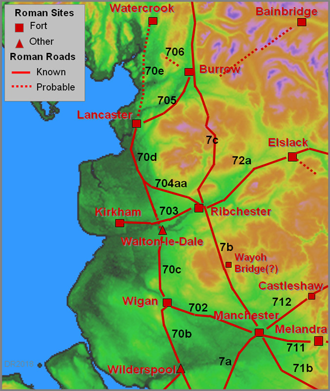
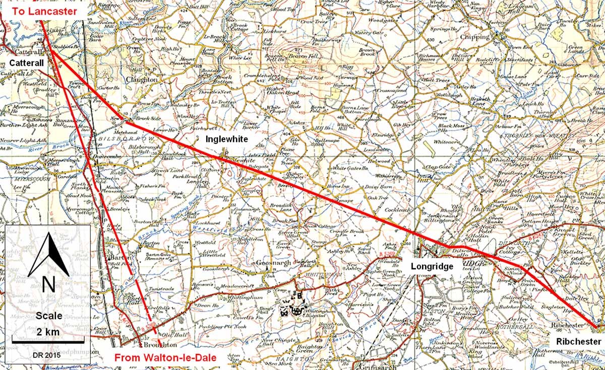
The Roman Road from Ribchester to Catterall (for Lancaster)
Margary Number: 704aa (unofficial)
Distance: 10.7 miles (23.25 miles to Lancaster)
How did the Romans get from Ribchester to Lancaster? This has been one of Lancashire's biggest puzzles for over 150 years. These were the county's most important Roman sites so good communications between them must have been essential.
Suggestions of a route were shown on the First Edition Ordnance Survey Maps of c. 1850. These depicted "Ancient Causeways" both over Longridge Fell and approaching Galgate from the village of Street. From that day on there has been endless speculation as to the route taken between these two Roman sites but hard evidence was remarkably elusive. The answer was simple - the road took a different course altogether - it went via Garstang
Using Lidar imagery from the Environment Agency, David Ratledge was able to discover the actual route of this missing road. The answer was surprising. Rather than following the Ordnance Survey route, it took a very sensible and economical route via Longridge and Inglewhite to Catterall, near Garstang. Here it joined another Roman Road, the main road from the south heading to Lancaster.
The alignments used are typical of Roman engineering, running straight for several miles but cleverly dog-legging up to Longridge to reduce the gradient. Site visits and trial pits have confirmed it is real with several stretches surviving well even though the Romans stopped maintaining it over 1600 years ago!
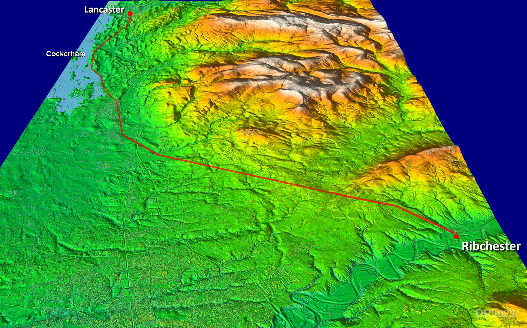
NEW 2023 -- 3D Lidar Video Flyover - Ribchester to Lancaster -the full route
3D Oblique Lidar View - Ribchester to Lancaster
Certainly not a direct route. It would appear that a coastal connection at Cockerham was somehow important. Cockerham was coastal up to as recently as a few hundred years ago.
Click for larger view
3D Oblique Lidar View - Ribchester to Pinfold, Longridge Road
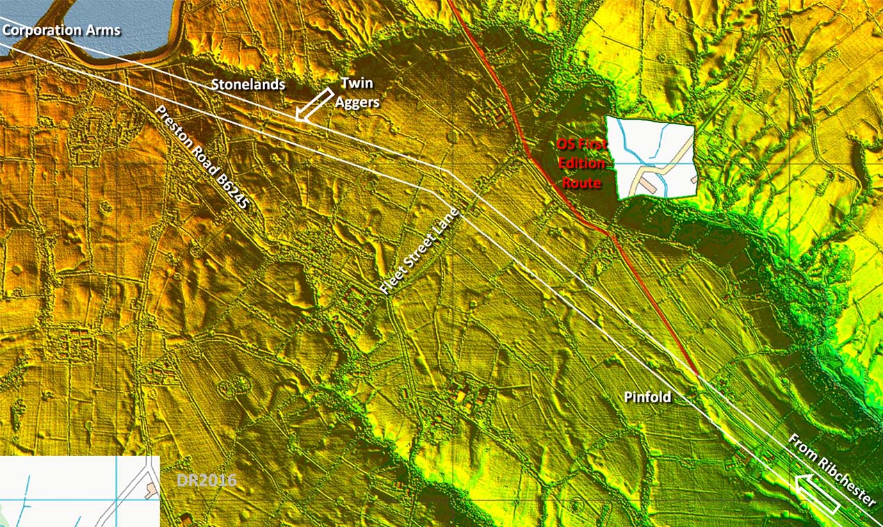
The B6243 indicates the line initially from Ribchester but the agger seems to have been slightly to the west of the modern road near Singleton House. In fact the front boundary wall of Singleton House aligns with the Roman agger rather than the modern road.
The first alignment is straight to beyond Fleet Street Lane (see below). However, at Pinfold Farm & Cottages the OS First Edition route doglegs off to the East and is marked up and over the fell as "Supposed Roman Road" and then as "Ancient Causeway" beyond. This was always puzzling at it leads to a high crossing of Longridge Fell with a steep drop on the northern side. A situation doubted by Margary.
The basis for the OS change of direction seems to have been the "agger" at Ward Green. Reexamining this with hindsight then this feature appears to more of a depression than an agger.
The OS route must now be regarded as almost certainly incorrect and Margary 704 as non-existent.
Click for larger view
Lidar - Pinfold to Corporation Arms
Reality is that it the road carried straight on at Pinfold crossing Fleet Street Lane and passing just to the east of Setters Cottage (SD 6306/3688). It changed alignment about 185 metres beyond here at approximately SD 629/370 making a small turn towards Longridge and a much more sensible place to cross the ridge of Longridge Fell. The aggers both before Stonelands and after show up prominently on this Lidar plot. See next image for an explanation of the "twin aggers".
Fleet Street Lane is also a good clue that there is a road here somewhere. Fleet Street would be a good name for a road going to Lancaster.
Click for larger view
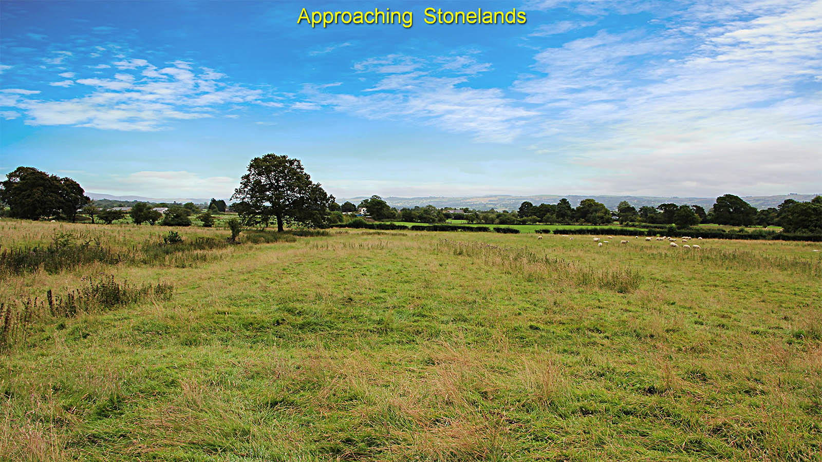
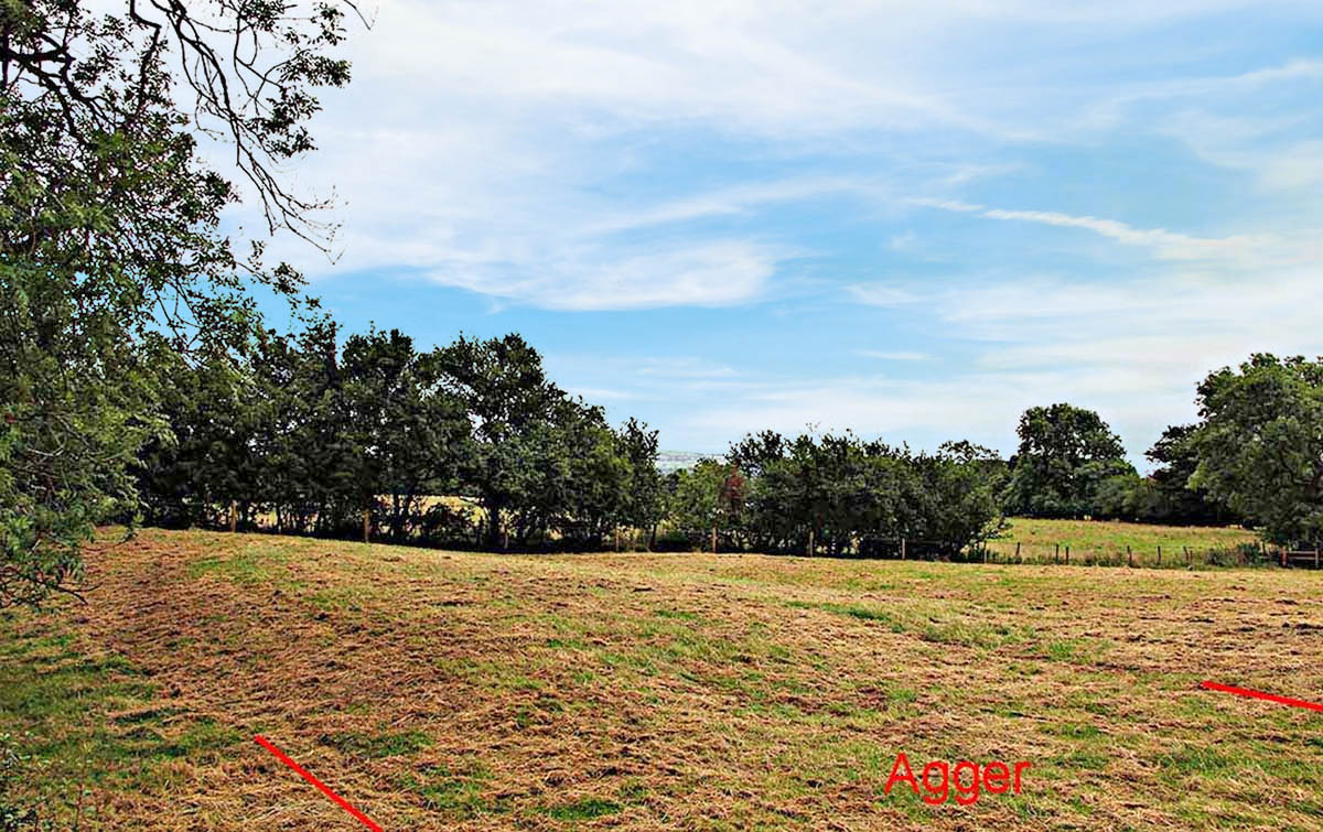
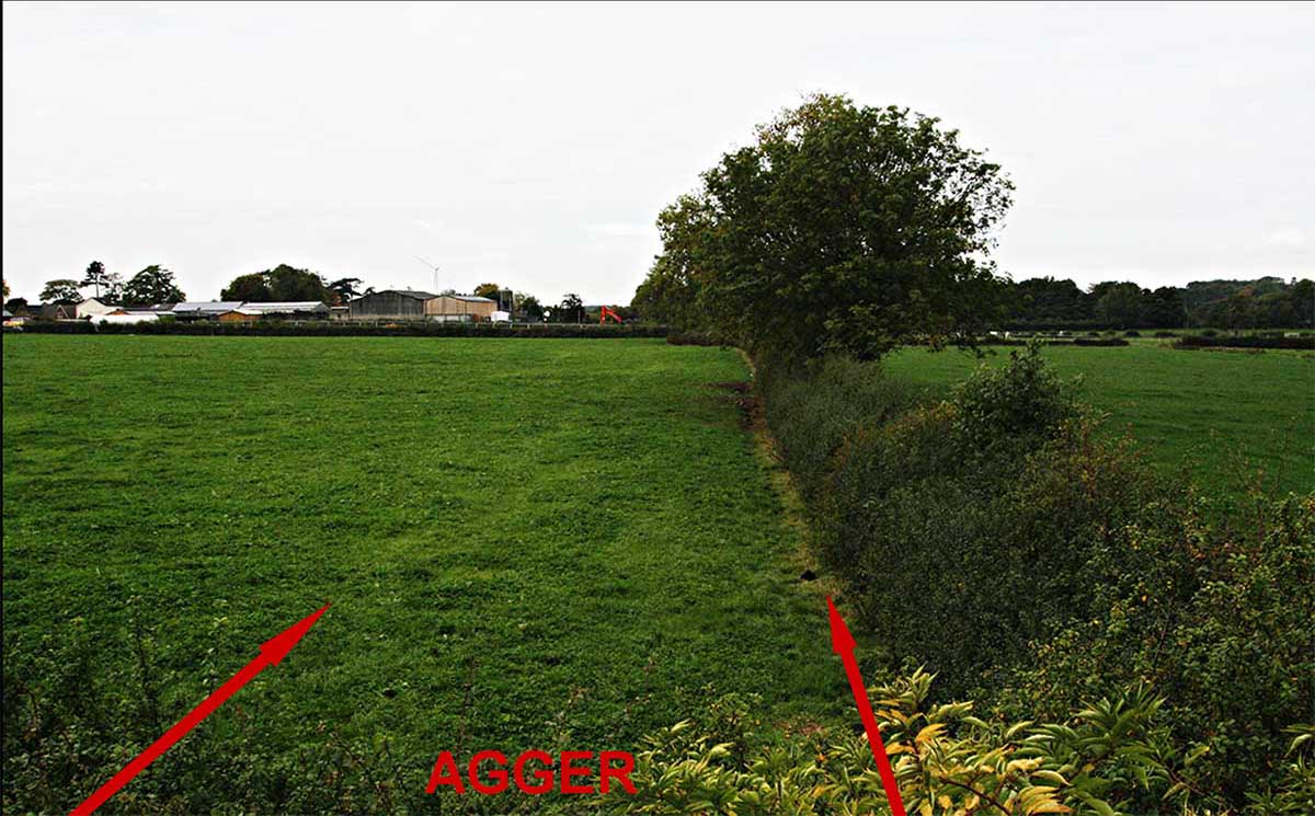
Agger approaching Stonelands Farm (SD6261/3707 to SD6245/3712)
This stretch is just west of the public footpath and is remarkable. This is the first indication from Longridge of how massive the agger of this road was. This was certainly a major highway.
Where the picture was taken an old field boundary crosses from left to right. The removal of this has actually cut a section through the agger which is at least 0.5 metres high.
This view is looking back towards Ribchester.
Note: This length of agger and that in the next image appear to be a later upgrade to the original road and was built alongside the original. The original agger is on the left here. Given the date for the Milestone (see below) we could reasonably date the construction of this new length to c. 300AD.
Click for larger view
Agger in the garden at Stonelands (SD6244/3713)
This is a continuation of the above on the other side of the hedge into Stonelands garden. It can be viewed from the public footpath.
Again its size and height is remarkable
Click for larger view
Re-erected milestone at Stonelands - not in original position (SD 62307/37134)
Dedicated to Emperor Maximian c. 300 AD. The inscription now is barely discernable but was recorded as
by David Shotter & Patrick Tostevin, LCAS Transactions VOL 107 2011 P117-118.
Notes: No distance is recorded or has survived but it would fit perfectly with 2 miles (to Ribchester). The authors did not know of this road then and reported it as being from the road to Burrow. This would represent a move of 2 miles and it is surely more likely that it is from this road - a move of metres rather than miles.
My thanks are due to Margaret Edwards for providing me a copy of the above report, which set in motion a train of events that lead me to the tracing of this road.
Note: this milestone has all the appearance of an "inverted" milestone. The current top is decidedly squarish as is more normal for the base. In all likelihood it would have been the other way up originally with probably an inscription for an earlier Emperor. So rather than obtaining another stone it was easier to turn it upside down and re-carve a new inscription on the new top. Thanks to Bryn Gethin for explaining "inverted" milestones and therefore the odd shape of this one.
Click for larger view
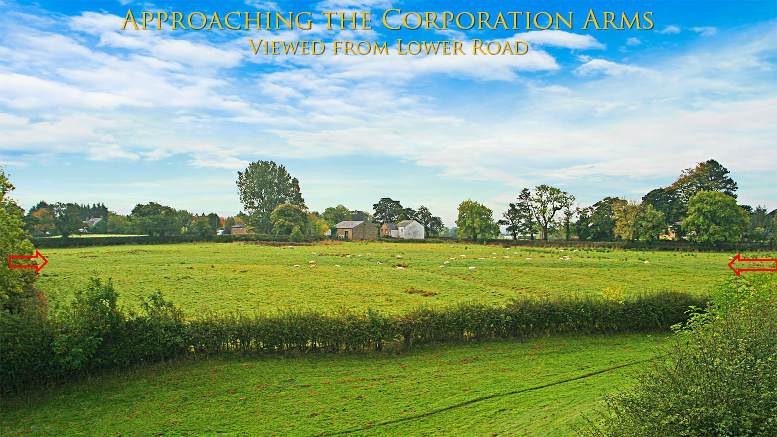
Agger between Stonelands and the Corporation Arms (SD6225/3720 to SD 6204/3727)
This stretch is clearly visible from the B6243 and again is very prominent. From here the logic of this alignment becomes obvious - the route chosen avoids the deep valley of Page Brook to the east (left).
Click for larger view
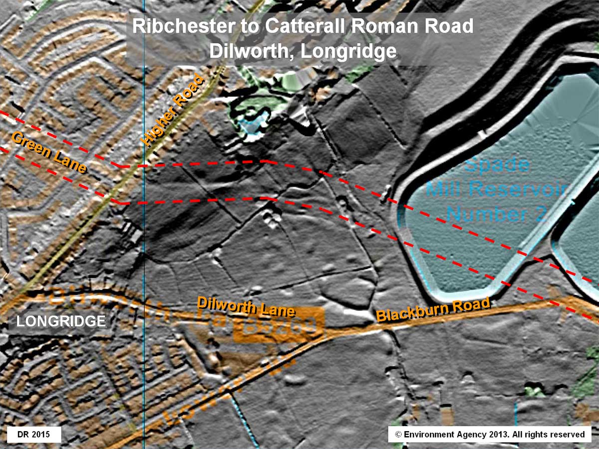
Ascent to Higher Road, Dilworth
Beyond the B6243 its course is marked by the north-east boundary of the Corporation Arms but does not become evident in the Lidar data until crossing the fields at Dilworth.
It begins a new short alignment at SD 6131/3754 to ease the gradient of the climb by cleverly angling across the slope. Typical Roman engineering. It is aiming for what is now the junction of Higher Road and Green Lane at SD6095/3753.
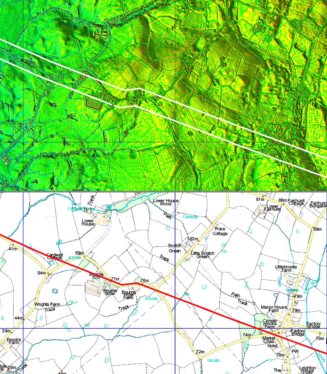
The main alignment now begins here aiming in the direction of Inglewhite Road/Alston Arms and all the way to the River Brock. The view ahead from Green lane is excellent but Green Lane itself is probably slightly off the line.
This new alignment is parallel to the alignment passing Stonelands - again a typical Roman characteristic. The sighting point from Green Lane is likely to have been the high ground west of Inglewhite around Bourne Brow and then sighted onwards down to the Brock.
Click for larger view
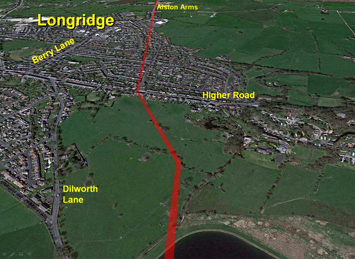
Dilworth, Longridge - aerial
Oblique aerial courtesy of Google Earth of the route crossing Longridge.
These fields at Dilworth are subject to housing development by Taylor-Wimpey and it must be assumed this length of road, having survived for nearly 2000 years, will soon be or has already been destroyed. I assume no watching brief will have been carried out.
Click for larger view
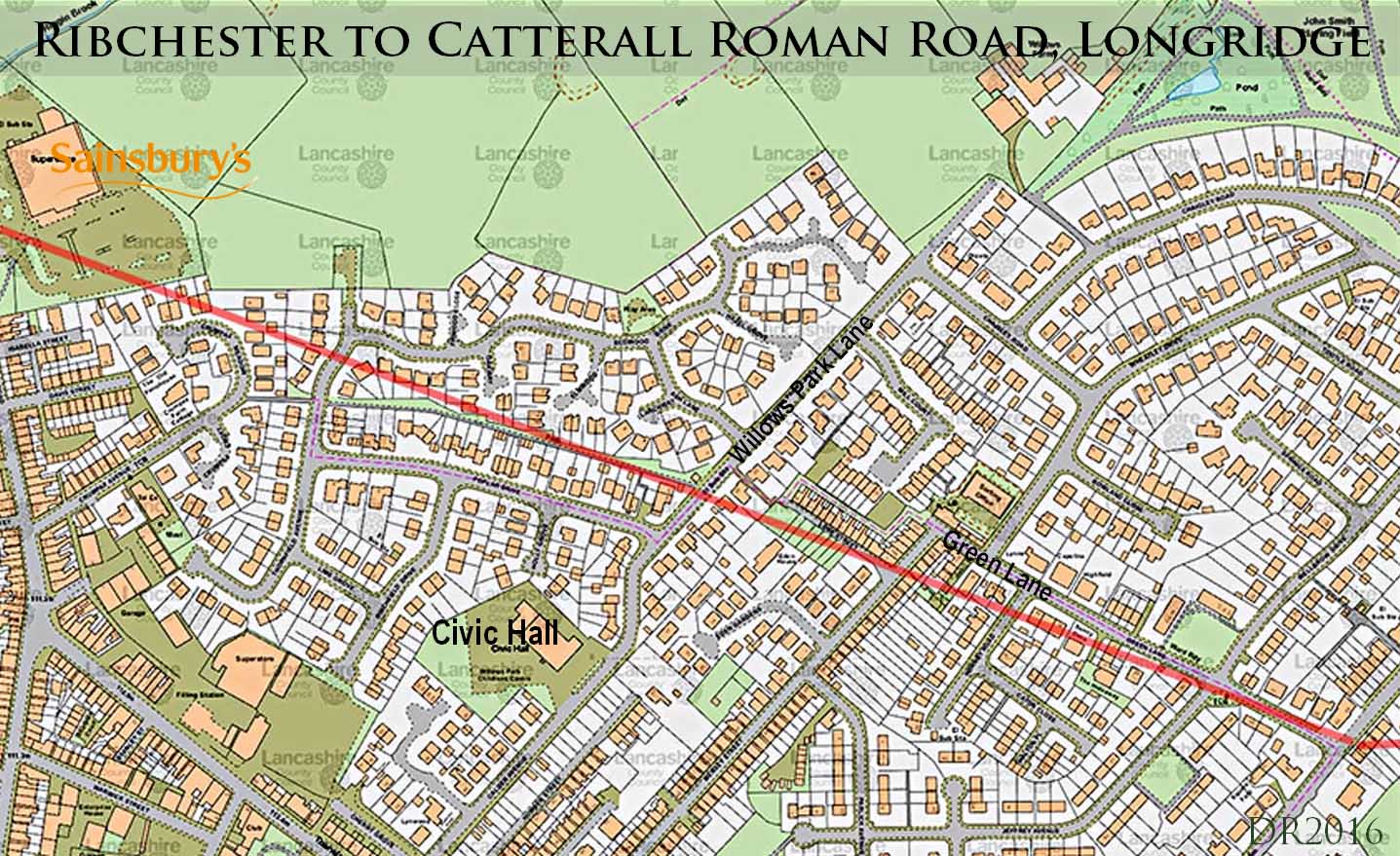
Route Map - Longridge
Green Lane is not exactly on the line but close.
In the gardens at Lune Street, a rockery was built with the stones from the road - personal comment from a former resident there..
The footpath at the rear of Poplar Drive seems to mark the road's course.
It is a shame that when Sainsbury's was constructed this road was unknown and no watching brief was carried out.
Click for larger view
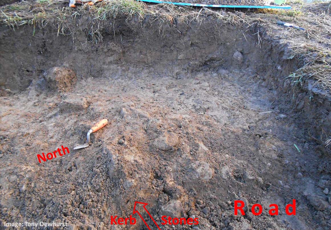
Excavation at Ashley Hall (SD58795 38355)
A private excavation was carried out by land owner Tony Dewhurst at Ashley Hall, believed to be in January 2018.. What was found was thought to be part of the road. Not a lot had survived but perhaps a line of edging or kerb stones was revealed.
Image Tony Dewhurst
Click for larger view
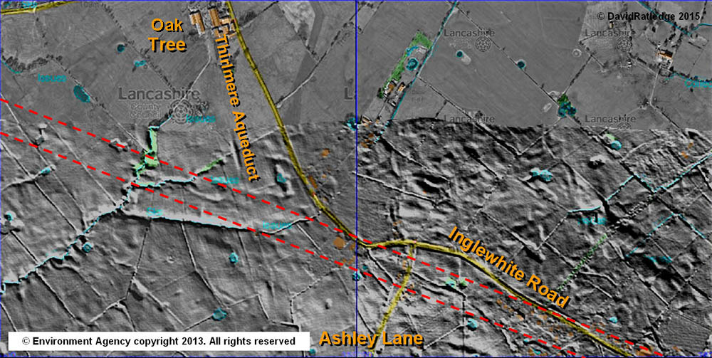
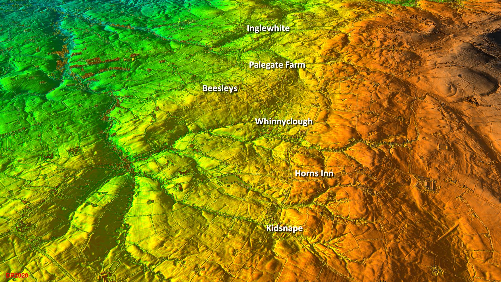
Lidar - Inglewhite Road to Kidsnape
It was the spotting of this section of road on the Lidar data that made me realise the road was not returning to the traditional route via Street but was continuing on towards Inglewhite. Note this course was undetectable on the original Environment Agency Lidar images - the default illumination angle renders the road invisible. It was only when I changed the illumination angle to be from the south-west did it pop into view.
I haven't found any parts of this length that have survived well enough to be obvious on the ground.
Click for larger view
Lancashire Record Office Document
Following the press publicity I received for this "new" road, I was informed by Neil Airey about a very old document for the boundaries of the lands of Kidsnape. This document was held by Lancashire Record Office and was dated to around 1200AD. This referred to an "old causeway". A causeway described as "old" at this date could only be the Roman road.
Wiki Definition : "In the Middle Ages, especially under the European feudal system, feoffment or enfeoffment was the deed by which a person was given land in exchange for a pledge of service."
I was subsequently contacted by Janet Edmunds, a local historian formerly living in Goosnargh for nearly 40 years and was on the committee of the Lancashire Archaeological Society. She had also noted this document and tried to work out the boundaries using the OS "Ancient Causeway" route via the Derby arms. She wrote "..when I tried to work out Kidsnape bounds from the description using that road, I failed for the north east part. I have now marked your line of the road on the 1844 map and the bounds work well, so your discovery is a great help."
LCC Reference number: DDKS/1/39 Title: Feoffment of land in Kidsnape, Goosnargh Date: n.d. [c.1200] Description: (1) Robert, son of Bernard, and his heirs (2) Geoffrey of Barton and his heirs The boundary commencing at Crokston [Cragstone] and running as far as the old causeway; thence to the ditch between Fpharmonhowra and Fpharmonheve as far as Cringbroke [Cringlebrook], from there to Kidsgrove brook, to the outlying clough to the north, to the moor of Lotemos stream, and then following the stream to Tynbersnapeheuet and across that to meet the first named boundary; with easements in Goosnargh and common pasture in Threlfall, saving to (1) his mill at Threlfall and his falcon. Witnesses: Walter son of Osbert, Mathew of Billborg, Halthern of Barton, Bernard, son of Bernard, William, son of Houtkel, William, son of Coterl, Herbert, son of Grimbald and Grimbald and Richard his brothers. Rent: 6d. p.a. payable at the feast of St. Martin.
Agger crossing Kidsnape Farm
West of Kidsnape Brook, the agger is clearly visible due to the difference in grass overlying it. Thanks are due to Ian Milnes for organising access to the private farm. We were able to dig a few trial pits and the road was found about 30cm below the surface.
Click for larger view
Lidar and aerial composite - Kidsnape to Inglewhite
The Lidar originally ran out at Kidsnape but the new coverage has filled in the gap and the oute is obvious all the way now.
Just to confuse matters a modern pipeline runs parallel to the road crossing Horns Lane about 75 metres further north-east.
Click for larger view
Across Horns Lane SD5718/3900 to SD5706/3905
The agger survives in several places and is visible on the ground beyond Horns Lane.
This stretch can be seen from a public footpath off Ford Lane (off Horns Lane). The agger is visible across the field - Ribchester is to right on this picture.
Click for larger view
Across Horns Lane (SD 5706/3905)
Where the agger above emerges into the next field, the swell of the agger is very obvious in the hedge line . Not only is the swell of the agger obvious but the grass is a totally different colour.
Continuing to left of the picture then the descent to Whinnyclough Brook begins - see next photo.
Click for larger view
Whinnyclough Beck
The descent to Whinnyclough Book is a cutting rather than a built up agger. This is looking north-west. This descent is about 10 metres off line so the route angled off the alignment to get to the best crossing point. There is a faint trace on the far bank to indicate it rejoining the true alignment. This would make the probable crossing point at SD5695/3907.
Along side this stretch is where a modern pipeline runs parallel - on the right side of this image near the hedge.
Click for larger view
Lidar approaching Inglewhite
One of the clearest runs of Lidar evidence showing that here the road has survived extremely well. It also indicates a very slight change of direction at Palegate Farm. This is one of the few names on the route with a possible road derivation and could perhaps derive from the grass on the road being a "paler" colour.
The route is so obvious I haven't bothered showing the line.
Click for larger view
Sparling Brook looking SE
This section is well worth a visit and is easily accessed by a public footpath opposite School House Barn. In the space of 100 metres there is an agger, a cutting and the remains of a bridge abutment.
The swell of the bridge abutment is an amazing survivor (SD5534/3972).
To the west of this abutment the road is first in a shallow cutting and then resumes as a normal agger towards the road, marked by a large tree (behind the camera in this picture which was taken looking back to Ribchester).
Click for larger view
Factory Brook - Embankment on the west bank
The embankment of the road is very obvious on the west bank where it crosses Factory Brook. The height indicates that there must have been a bridge here but no abutments have survived. The line of the road is towards the big tree in the middle of the picture.
Note this is private land with no public access. Thanks are due to John Roddam (pictured) for arranging permission with the farmer to get to this spot. John is standing approximately on the line of the south road ditch with the embankment in front of him.
Click for larger view
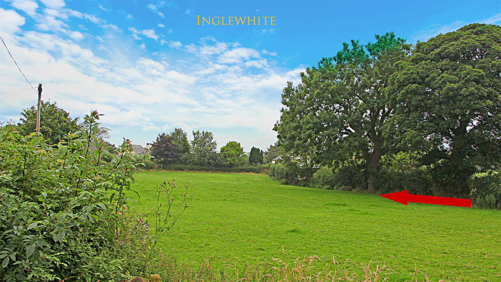
Inglewhite (SD5472/3992)
This stretch of agger is just off the village green and this view is from the side of Chapel House. It aligns with the short road on the western side of the green passing The Barn on the Green. It is amazing no one spotted this stretch.
In the floods of December 2016 the field here was flooded with just the agger standing proud above the water level.
Beyond Inglewhite there is another gap in the Lidar coverage but there is some limited aerial evidence for the road near Bourne Brow. However, there is no real reason for the road to have deviated off the straight alignment.
Click for larger view
Bourne Brow - Lidar and Route Map
North-west of Inglewhite had a gap in the first edition Lidar coverage. This has now been flled in with the series 2 coverage and we now plot thr route there with only a modicum of interpolation..
Some sort of dog-leg was to be expected for the descent of the hill there. It looks like the modern road, also dropping down the hill, shares part of the route.
Click for larger view
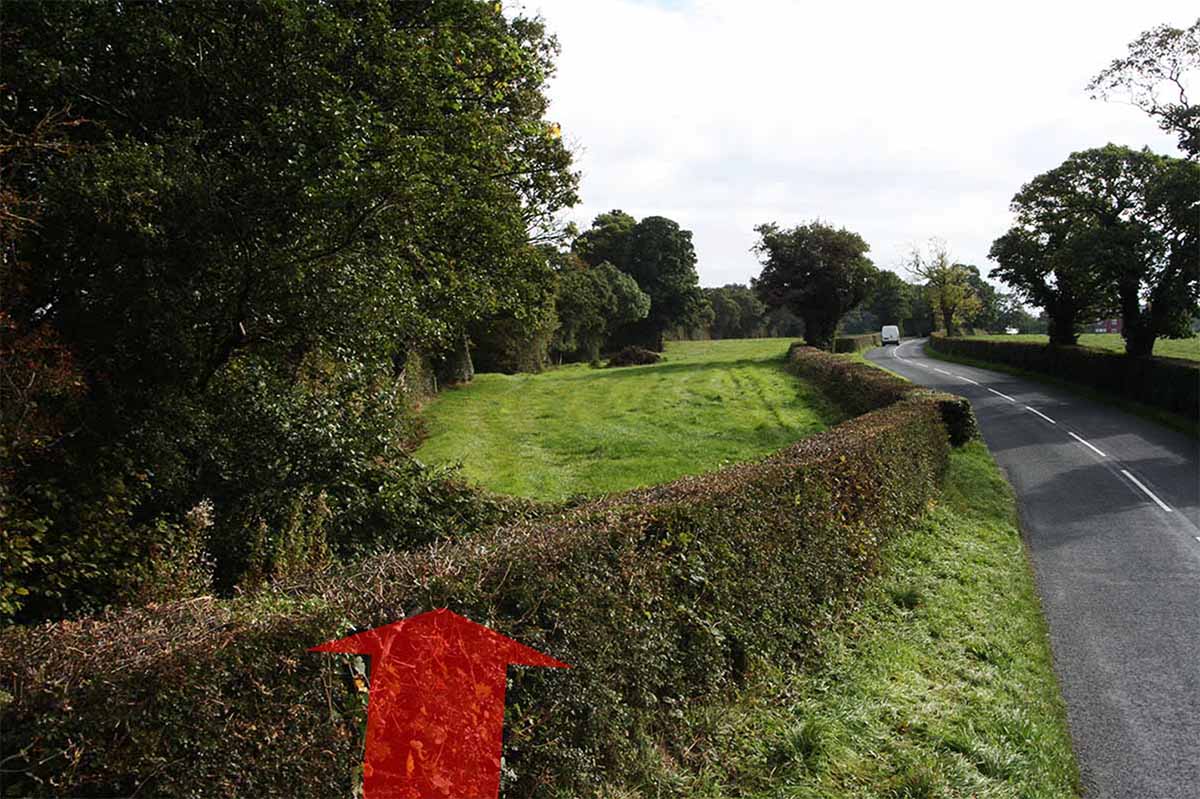
Lydiate Lane (south of the River Brock) looking SE (SD5292/4057)
The straight alignment from Inglewhite is probably marked by this field boundary alongside a small ditch/stream merging into Lydiate Lane at the point of the photo. The photo is looking back towards Ribchester.
Click for larger view
Lydiate Lane - probable road stones in field
Behind the trees in the view above is this collection of stones. The location would fit exactly for them being the road's foundation stones. The rest of the field was stone free. This would suggest the ditch shown above was the west ditch of the road. Thanks to Andy Jackson for spotting these.
Image: Andy Jackson
Click for larger view
River Brock Crossing (SD5210/4098)
Unusually, this crossing point marks a change of alignment. The Roman engineers normally used high intervisible points but not in this case. The River Brock is by far the largest river on the road so the selected crossing point must have been of sufficient importance to dictate where a change course was to take place.
The Brock is a vigorous river and no abutments have survived. However, on the north bank, opposite Trout Row Cottages, a cutting leads down to the crossing point. The height of the cutting matches a bridge rather than for a ford. This was to be expected as the Brock is often subject to rapid increases in depth with run-off from the Bowland Fells so fording would have been unpredictable.
This can be viewed from the public footpath in front of Trout Row Cottage.
Click for larger view
River Brock Crossing - north ascent
The ascent from the north bridge abutment up to the field level has survived extremely well. As is common for Roman engineering they have reduced the steepness of the climb by curving its course.
Note this is private land and it not publicly accessible.
Click for larger view
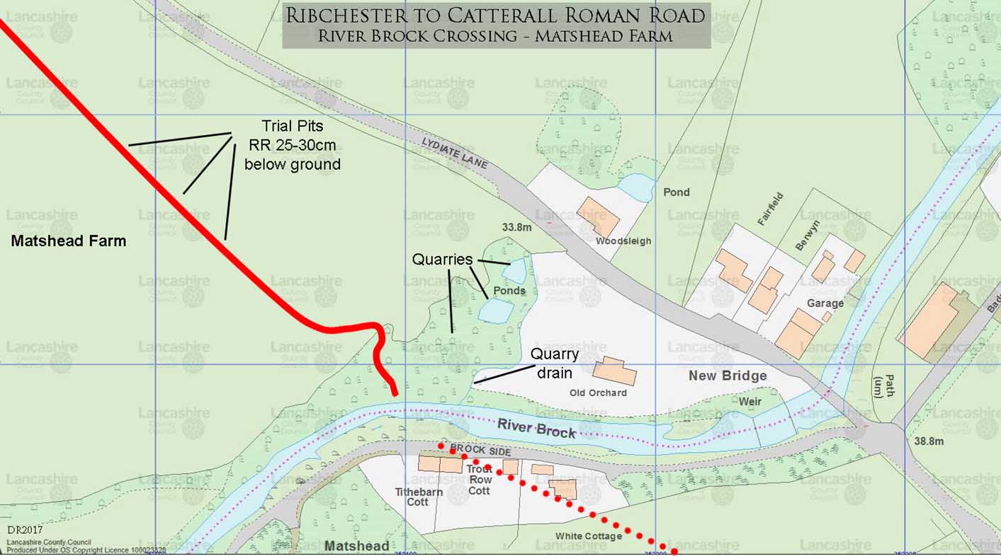
River Brock Crossing (Plan)
The climb up from the bridge height on the north bank is visible in the previous image as a typical dogleg to ease the gradient. Thanks due to Ian Milnes for organising access to Matshead Farm (private land) to inspect this. We were also able to dig several trial pits along the agger north of the crossing and the road appeared to have survived well about 25 to 30cm below the surface.
Adjacent to the bridge site, on the east side, are quarries which have had a drain cut to the river, presumably to stop flooding. Whether these quarries were Roman in date was impossible to tell.
Click for larger view
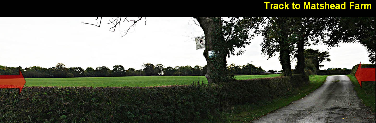
Matshead Farm off Lydiate Lane (SD 5200/4107 to 5190/4117)
It is very obvious where the Roman road crosses the track to Matshead Farm - there is a very distinct rise over the agger. In the fields to the south (left) the line of the agger is clear too and visible from the public road. The stretch across the fields is even visible in Google Streetview.
Click for larger view
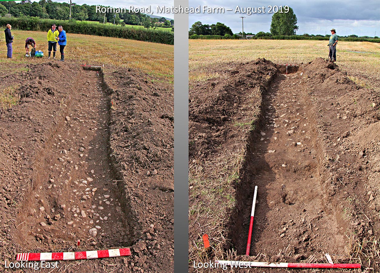
Excavation by Wyre AS, 11th/12th August 2019, Matshead Farm - Trench Views (SD51920 41156)
Dave Hampson and the team from Wyre Archaeology did a brilliant job in only 2 days to expose a full section across the road for the first time in over 1600 years! This had to be carried out between crops at very short notice. Thanks are due to the landowner, Derek Cornthwaite, for granting us access.
Summary of Results:
Road surface approximately 300mm below surface.
North side of trench, road had been disturbed by field drain – south side undisturbed/pristine.
Road width: 8 metres.
Road cambered.
Road material: river gravel/stone (almost certainly from the River Brock).
Surviving road 500mm thick at centre.
Road built on clay – no dark humus layer between stones and clay.
Bottom layer: larger stones (c. 200mm size) had been laid on clay surface.
Subsequent layers: gravel sizes 25mm to 150mm mixed.
Ditches: shape not obvious but filled with silt.
Click for larger view
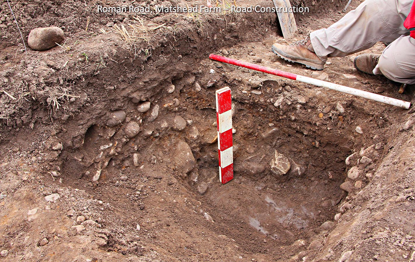
Excavation by Wyre AS, 11th/12th August 2019, Matshead Farm - Road Construction
On day 2, we (Wyre Archaeology) broke through the road near the centre. It needed a pick axe/mattock to get through it. It was built to last!
It had survived 500mm thick, built on clay - probably the natural level. Bigger stones had been laid on the clay first and then the road built up using river stones/gravle around 1 inch to 6 inches in size.
So we now know its size, construction and thickness - not bad in 2 days.
Click for larger view
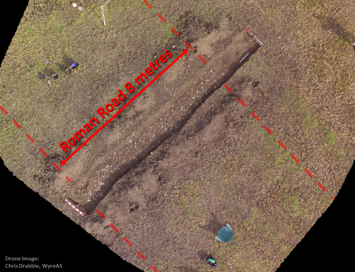
Excavation by Wyre AS, 11th/12th August 2019, Matshead Farm - Drone Shot
Before we broke through the road, Chris Drabble flew his drone over the site. This is a rectified mosaic view looking straight down. My chair can also be clearly seen!
Image: Chris Drabble
Click for larger view
Ducketts Lane looking NW (SD 5160/4147)
This length of Ducketts Lane overlies the Roman Road. Beyond Ducketts Lane, the motorway, railway and canal all cut through the road alignment - some faint traces appear to have survived between them but the agger resumes more clearly after the canal.
Click for larger view
Stubbins Lane looking north (SD 5043/4265)
Despite the Lidar showing aggers either side of Stubbins Lane they are remarkably difficult to see on the ground - the light needs to be in the right direction. This view north was taken with the camera at a height of 4 metres, which makes the agger a little more obvious.
Click for larger view
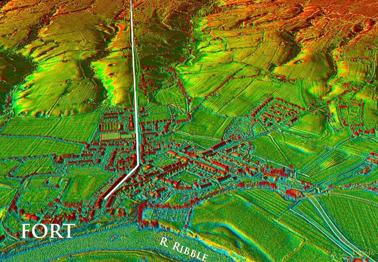
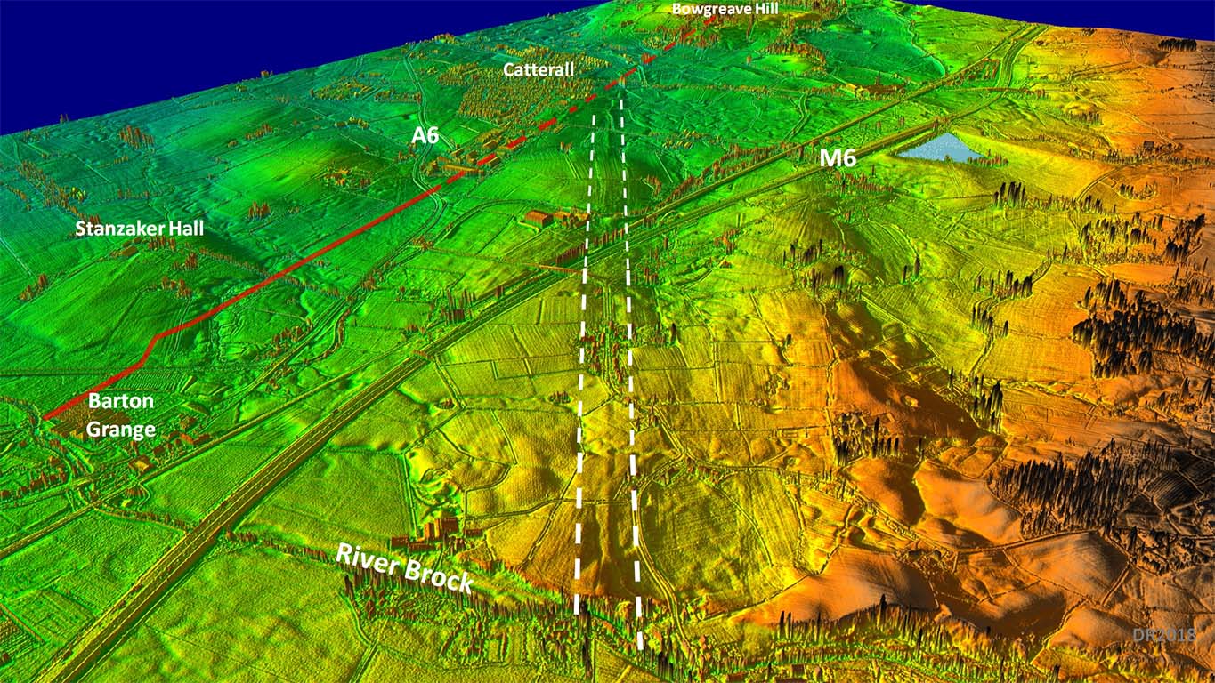
Lidar - River Brock to Catterall
The actual junction with the north-south road from Walton-le-Dale cannot be pin-pointed exactly here. The north-south road at this point has been much disturbed/covered by modern development so its position is only approximate here. Best estimate would place the junction at Stones Lane - a very appropriate name.
Note: I am aware of the Contrebis article that suggests Stones Lane is named after the Stones family that lived there.....but how did the Stones family get their name?
Roman Road Junction - probable at SD 5006 4299
Click for larger view
3D Oblique Lidar View - River Brock to Catterall
The journey to Lancaster would therefore be completed by using the Walton-le-Dale to Lancaster road (shown in red on the left) - proving the latter must have been there first. Following the recent discovery of the route of the road north of Garstang, the Ribchester to Lancaster distance is now known to be approximately 23.25 modern miles or 25 Roman miles.
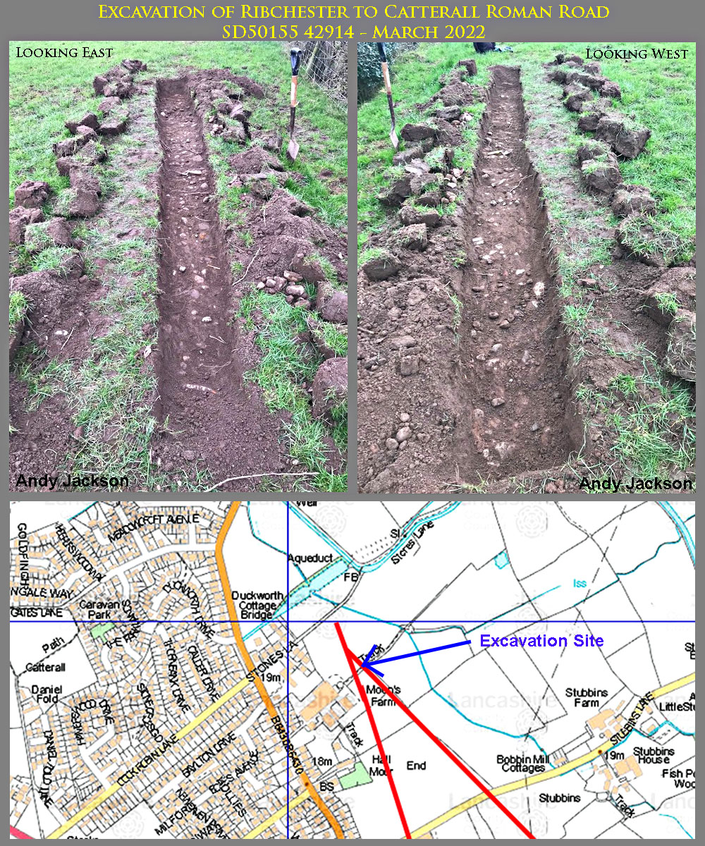
Excavation March 2022, Moon's Farm, SD50155 42914
A private excavation was carried out in March 2022 by my colleague Andy Jackson. The location was very close to its junction with the Roman road from Walton-le-Dale, just north of a track at Moon's Farm. The road was only 150mm below the surface and it had a slight camber. There was only time to excavate about 4.5 metres of the road but it was almost identical to that excavated at Matshead so most likely would have been 8 metres wide in total.
Lidar Image - Full Route
What a sensible route! Why did we ever think they would have headed via Beacon Fell? It looks like the Brock crossing point was what determined the precise alignment.
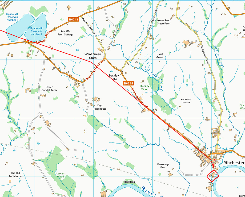
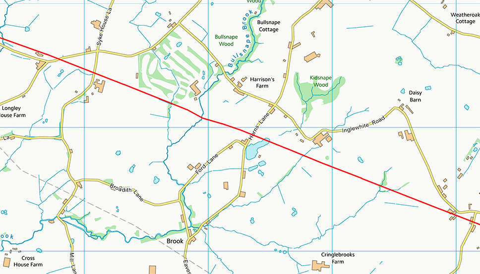
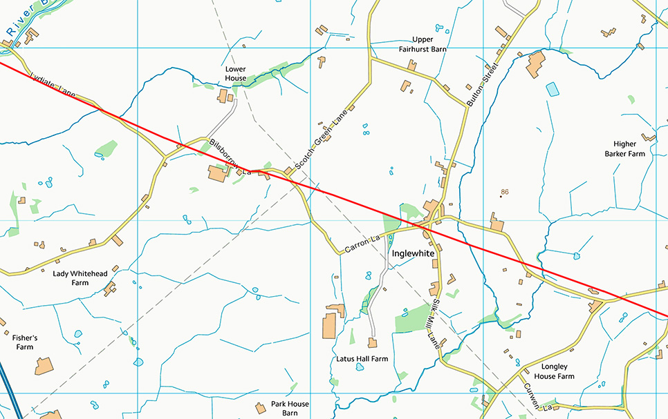
Maps
The following 5 maps cover the route in detail.
Click for larger view.

 by David Shotter & Patrick Tostevin, LCAS Transactions VOL 107 2011 P117-118.
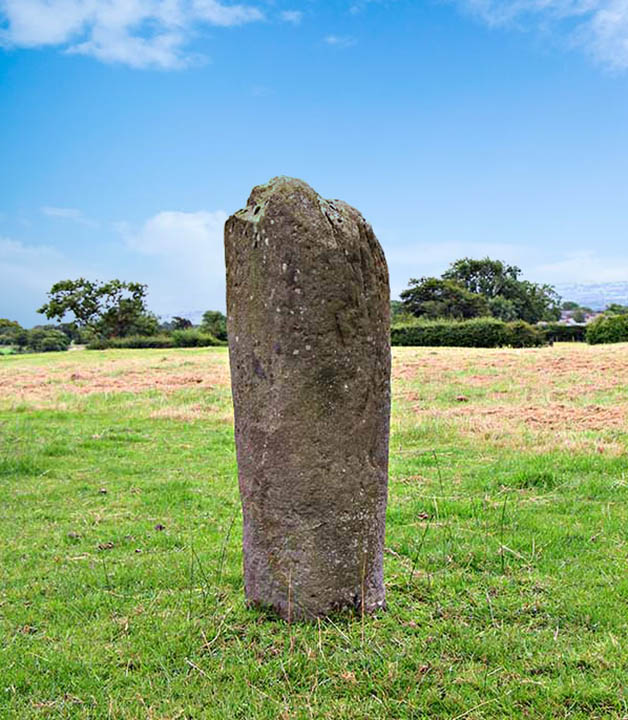


