 |
Cambridgeshire's Roman RoadsA Lidar Re-appraisalThe Roman road map for Cambridgeshire makes most sense when the extent of the Fens area in Roman times is depicted. The vast majority of the Roman roads keep to dry land. Only the Fen Causeway traversed the the Fens. What an incredible undertaking that must have been. Once constructed then presumably south of the causeway the land slowly became dryer and more habitable. The major road through the county though was of course Ermine Street. This was the main road from London to Lincoln and ultimately onwards to York. The road numbering system is based on that devised by Ivan Margary over 60 years ago. Although long out of date it is still the best we have. However, several roads in East Anglia were unknown to Margary and therefore have no numbers. Lidar, both 2D and 3D virtual reality models have been used extensively in appraising the alignment of the roads. This technique has proved an extremely efficient way of detecting linear feature such as Roman roads. Imagery derived from this data is often able to show clearly the surviving remains of the road agger, terraces, side ditches and cuttings, often where they cannot be identified easily on the ground through traditional fieldwork.
|
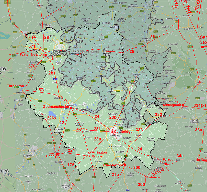 |
Road numbers are those allocated by Ivan Margary and the Fens extent from Pryor. |
IntroductionAlthough our route map, on the face of it, looks very familiar several gaps and refinements to the course of the roads have taken place. There is one "new" road from Sandy to Thrapston which passes through Cambridgeshire plus the two roads west from Arrington Bridge are essentially "new" ones too. The roads are shown overlaid with the probable extent of the Fens at the beginning of the Roman era, which explains the logic behind many of the routes they followed. The Roman road map is dominated by the three major towns: Cambridge, Godmanchester and Water Newton. These three all lie on the edge of what would have been the extensive Fens in the Roman era. The north-east of the County is largely empty of roads but water borne travel would have been far more practical and the three major towns would have all been navigable out to the sea. Cambridgeshire's Roman RoadsFor all the known routes in detail choose the appropriate page:-Ermine Street Braughing to Arrington Bridge, 2b Arrington Bridge, with a minor Roman settlement, was the halfway point from Braughing to Godmanchester. Arrington Bridge to Godmanchester, 2b, A very direct section to the Roman town on the south bank of the Ouse at Godmanchester. Godmanchester to Water Newton, 2b, Crossing the Ouse was the big obstacle and then the road keeps to the west of the Fens. Water Newton to Stamford, 2b, Probably the best surviving stretch of Ermine Street is to the north of Durobrivae. The Roman Roads around Cambridge Akeman Street, Cambridge to Ely(?), 23b A well-established Roman road as far as Ely but onwards to Littleport seems likely. Akeman Street, Cambridge to Ermine Street (Arrington Bridge), 23a A Roman road still much in use today. Cambridge to Godmanchester (Via Devana), 24 The so-called Via Devana and now one of Cambridgeshire's busiest roads. Cambridge to Ermine Street (via Cambourne), 231, Perhaps some doubt this road's authenticity but on balance probably Roman. Wixoe to Cambridge, 24, The route around Haverhill was a little uncertain which I think has been resolved now. Roman Roads around Godmanchester Godmanchester to Great Staughton Simple link road connecting Great Staughton to Ermine Street at Godmanchester. Godmanchester to Sandy (Bedfordshire),22 Originally thought to start west of Durobrivae but now known to link to the town's south-west gate. Godmanchester to Thrapston, 57a A puzzling start that runs parallel to Ermine Street before turning westwards.. Roman Roads around Water Newton The Fen Causeway, Margary 25 An amazing road across the fens and its probable extension onwards to the Icknield Way. Water Newton to Thrapston, 570 Another very direct route up the Nene Valley Water Newton to Laxton, 571 A road connecting Ermine Street to the extensive ironstone mines around Laxton King Street, Water Newton northwards, 26 A branch off Ermine Street providing a slightly shorter route to Lincoln Roman Roads west of Arrington Bridge, Wimpole Arrington Bridge to Sandy (Bedfordshire) Sandy is now known to have been an important settlement so a connection to Ermine Street was to be expected. Arrington Bridge to Stotfold (Hertfordshire) A continuation for RR23a linking from Ermine Street across to Stotford on RR22. Other Roman Roads The Icknield Way, Margary 333 Not always accepted as Roman but the course south of Icklingham exhibits classical Roman surveying. Sandy to Thrapston NEW ROAD Despite not starting or ending in the county over half of its length is in Cambridgeshire.
AcknowledgementsThanks are due to Mike Aerts for developing his bespoke "MAGIC" Lidar software that turns numbers into 3D virtual reality models Raw (ascii) Lidar is copyright DEFRA/The Environment Agency. The processed Lidar data shown here is copyright David Ratledge. Having said that, you are welcome to use any of the Lidar images providing a source reference is given. Mapping used is generally Ordnance Survey Opendata supplemented by Bing Mapping and Aerial Photography for selected areas. Google imagery has also been utilised.
References: Below are general references. Specific ones pertaining to a particular road are included on the appropriate web page. Ancient Cambridgeshire or an attempt to track the Roman and other Ancient Roads that passed through the county of Cambridgeshire, Babington, B.B. 1883. Roman Roads in Britain, Codrington, 1903/1918. (Bill Thayer's online version). Roman Roads in Britain, I.D. Margary, 1957. Way out of date but still the first "go to" source book. The Margary road numbers used here are from this book. Roman Cambridgeshire, David M. Browns,, 1977. Includes a Roman road map with Roman sites/finds. Roman Roads in the South-East Midlands, The Viatores, 1964. The Land of Boudica - Prehistoric and Roman Norfolk, John Davies, 2008. Comprehenisive study by the keeper of Archaeology at Norwich Castle Museum. Roman roads in the changing landscape of eastern England c.AD410 – 1850, James Albone, 2016. PhD thesis (University of East Anglia) - the Roman roads through time.
Contact: To contact David Ratledge regarding the Norfolk web pages, please email me.
|
|

|
|
|
Last update: January 2024 |
© David Ratledge |