
|
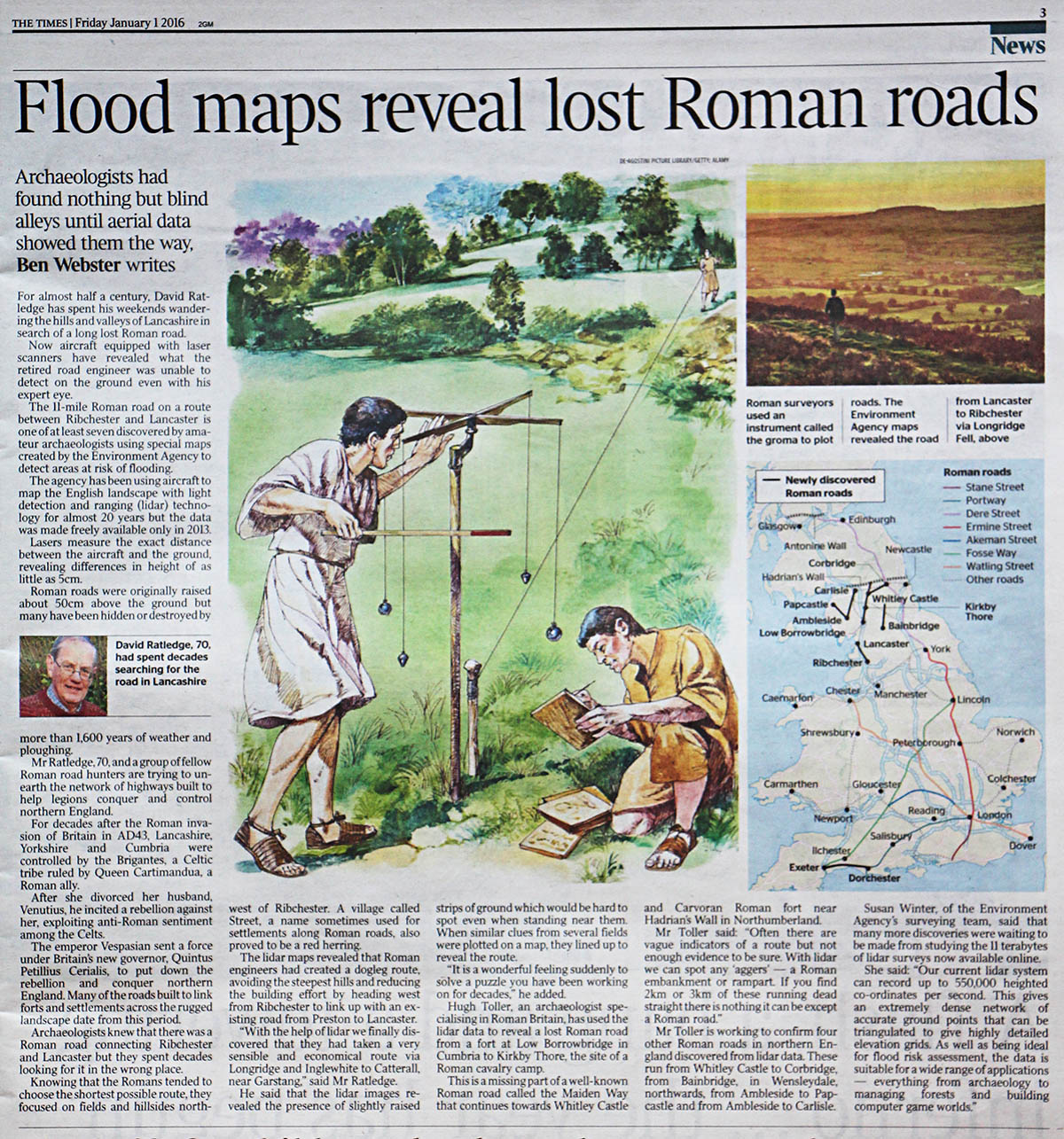
Britain's Roman RoadsA Lidar Re-appraisalThe last few years has seen a transformation in our understanding of the Roman road network largely as a consequence of LiDAR data becoming freely available. The use of LiDAR data (basically high precision height data) to reveal the course of Roman roads has been a great success throughout the country. Imagery derived from this data is often able to show clearly the surviving remains of the road agger, terraces, side ditches and cuttings, often where they cannot be identified on the ground through traditional fieldwork. Virtual reality 3D LiDAR models have been used extensively as these enable the viewer to look directly down the line of a road to trace its course. As a result lost roads have been found and many gaps and corrections have been made to the previously known roads. My thanks are due to Mike Aerts for developing bespoke software which has proved invaluable and has resulted in many discoveries.. Media articles including my work:- 2016: The Times- Flood maps reveal lost Roman roads |
|
|
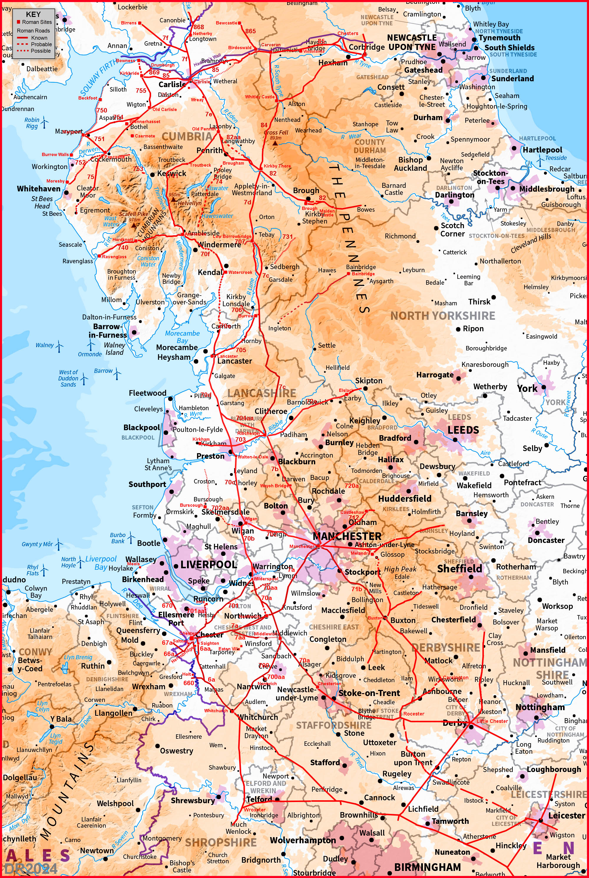
Northern EnglandNorthumberland - The Stanegate - Missing section locatedCumbria - Several updates including High Street (RIP?)Lancashire & Greater Manchester - New Milestone Discovery 2024Cheshire - Some updates for 2020Derbyshire - NEW for 2026Manchester/Derbyshire/Yorkshire- Manchester to Doncaster? NEW ROADNorth-West Roman Road Map Update your Ordnance Survey map! 2024 Version
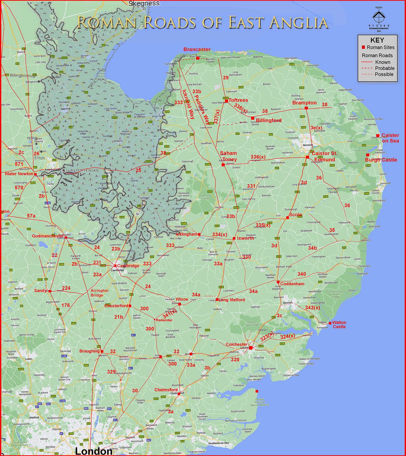
Midlands & East AngliaLeicestershire, The so-called Via Devana is locatedNorfolk - Some big updates in 2025!Suffolk - A "new" road at long last solves the Sitomagus puzzle!Cambridgeshire - Last piece of East Anglia.Essex - Updated 2025. Harlow town sorted at last!Hertfordshire - Updated 2025.East Anglia Roman Road Map - 2025 edition
South WestDevon - Roman Roads around Exeter (PDF) - note slow to load!Devon - A new road from Exeter to Watchet (probably). Video FlyoverDevon - Exeter to North Tawton Video Flyover
|
Full County areas currently available are shown in red. |
|

|
|
BackgroundThe original version of these web pages went online over 20 years ago and covered just Lancashire. With the advent of LiDAR finding and tracing Roman Roads has become a much more efficient process and enabled the area now covered to include the whole of the North West of England and East Anglia too. Thanks are due to Neil Buckley for assisting me in compiling Cheshire's Roman roads. I have taken a county based approach as this seems the most logical and easiest to understand. Historic Environment Records (HER) are generally organised on a county-wide basis too but with the exception of the National Parks which tend to have their own planning departments. Earlier versions of some of these pages are available on the Roman Road Research Association's web site but the most up to date version are to be found here. I will attempt to keep updates as speedy as possible. So if you know something I have missed then please get in touch.
AcknowledgementsRaw (ascii) Lidar is copyright The Environment Agency. The processed Lidar data shown here is copyright David Ratledge. Having said that, you are welcome to use any of the Lidar images providing a source reference is given. Mapping used is generally Ordnance Survey Opendata supplemented by Bing Mapping and Aerial Photography for selected areas. Google imagery has also been utilised.
References & Links:Below are general references/links. Specific ones pertaining to a particular county or road are included on the appropriate web page(s). Ordnance Survey Map of Roman Britain - not up-to-date, has several omissions and errors but provides an overall picture. Roman Roads in Britain, Codrington, 1903/1918. Bill Thayer's excellent online version. Roman Roads in Britain, I.D. Margary, 1957. Still the primary source but really needs updating. The "Margary" road numbers are from this book. Roman Roads & Walls in Northern Britain, John Poulter, 2010. Suggestions on how the roads were planned and set-out. The Secret History of the Roman Roads of Britain, M.C. Bishop, 2014. Excellent introduction and even answers the question how long would it take to build a road. The Roman Roads Research Association The Roman Roads Research Association was formed to advance knowledge of the Roman road network and promote the study of Roman roads and Roman heritage throughout the British Isles. Contact:To contact David Ratledge regarding these web pages, please email
|
|

|
|
|
Last update: March 2026 |
© David Ratledge |