Introduction
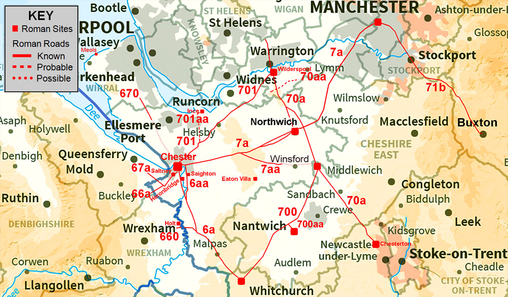
The Roman road map is dominated by Chester as it was an important Legionary centre not just for North-West England but North Wales too. The east of the County is suspiciously empty - perhaps more work is required here. It would also be expected that Eaton Villa, the only such known villa in the north-west, would be reasonably close to a road. The forthcoming full Lidar coverage for England may help with these and other remaining puzzles.
Cheshire's Roman Roads.
For all the known routes in detail choose the appropriate page:-
The Roman Roads around Chester (in clockwise order)
Chester to Wilderspool, Margary 701 Very difficult road to pin down due it being overlaid by modern roads for most of its length.
Chester to Northwich, Margary 7a Turned out to be more complicated than previously thought with almost certainly two routes at it eastern end.
Chester to Whitchurch, Margary 6a Just its middle portion was uncertain but perhaps a viable route has now been located.
Chester to Aldford (East Bank), Margary 6aa A long suspected road and at last we have some Lidar evidence for its route. What looks like a "new" fort turned up too.
Chester to North Wales, Margary 66a & 67a Suggestion for the initial stage of what must have been the main road into Wales.
Chester to the Wirral, Margary 670 Not too certain a route but what evidence there is we have explored using Lidar.
Bridge Trafford to Ince. Margary 701aa Again not a great deal of evidence but the fortlet at Ince must surely have a road connection back to Chester.
Other Roman Roads of Cheshire
Roman road(s) near Holt, Margary 660 A couple of options for how Holt was connected into the known road network.
Kelsall to Middlewich, Margary 7aa Route Determined. At last we have the full route to Middlewich
King Street (Wilderspool to Middlewich to Chesterton), Margary 70a The major North-south route through the county. Progress has been made on locating its southern half.
Middlewich to Whitchurch, Margary 700 Excellent progress has been made on locating the missing length of this road - particularly at it southern end.
Nantwich Link Road, Margary 700aa There had to be one and a good candidate has been located.
Possible Roman Roads
The North Cheshire Ridge Roman Road, Margary 70aa A very puzzling road. With the release of series 2 Lidar data (2021) the existence of this road is very doubtful.
Possible Roman Roads We look at four often suggested possible Roman roads but the evidence is scarce at best.
Acknowledgements
Top of the list for our thanks must be Moya Watson, Historic Environment Record Officer for Cheshire Archaeology Planning Advisory Service. She has proved hugely helpful in meeting our many and varied requests which, when councils are hugely under-resourced, must have been the last thing she needed. We are immensely grateful. Thanks are also due to Adrian Waddelove for many helpful suggestions and making us aware of various sources of information. He also was kind enough to proof read some of the early drafts - but of course any remaining errors are our responsibility. Thanks also for Mike Haken, chair of the Roman Roads Research Association. He was able to provide several research papers and background sources that made our task much easier.
Raw (ascii) Lidar is copyright The Environment Agency. The processed Lidar data shown here is copyright David Ratledge. Having said that, you are welcome to use any of the Lidar images providing a source reference is given. Thanks are due to Mike Aerts for developing his bespoke "MAGIC" Lidar software that turns numbers into pictures.
Mapping used is generally Ordnance Survey Opendata supplemented by Bing Mapping and Aerial Photography for selected areas. Google imagery has also been utilised.
References:
Below are general references. Specific ones pertaining to a particular road are included on the appropriate web page.
Roman Cheshire, W.T.Watkin 1886 (reprinted 1974). Primary source of historical information on Roman Cheshire and its roads.
Roman Roads in Britain, Codrington, 1903/1918. (Bill Thayer's excellent
online version - Chapter III covers Cheshire)
Roman Cheshire (Vol. 2), F.H. Thompson, 1965. Not big on roads but provides a useful background.
Roman Roads in Britain, I.D. Margary, 1957. Way out of date but still the first "go to" source book. The Margary road numbers are from this book.
Roman Roads in Britain, I.D. Margary, 1957. Way out of date but still the first "go to" source book. The Margary road numbers are from this book.
Living on the Edge of Empire - Models, Methodology & Marginality, Ed Dr.Michael Nevell, 1999. Several chapters relevant to Cheshire.
Hidden Highways of Cheshire, R.J.A. Dutton, 1999. Dutton finds numerous Roman roads but which ones are real? Maps leave a lot to be desired.
Roman Roads of North East Wales & Cheshire, R.J.A Dutton, 2011. More of the same. Maps are neater drawn but still hopelessly inaccurate.
Revealing Cheshire's Past Web Site, Cheshire Archaeology Planning Service. The primary site for all Cheshire's historic records.
Lancashire & Cheshire's Roman Roads, A Second Lidar Reassessment, David Ratledge, Lancashire & Cheshire Antiquarian Society Transactions Volume 112, 2020
Contacts:
To contact David Ratledge or Neil Buckley regarding the Cheshire web pages, please email either of us:

> Return to Gazetteer
|