Roman Roads in Cumbria - Homepage |
|
Welcome to Cumbria's Roman Roads Web PagesThis review of Cumbria's Roman Roads was carried out over 3 years (2015-2017) and has made extensive use of Lidar to check the known and reveal some previously unknown roads. The site was triggered by a promise to the late Hugh Toller to complete the work he had started in the county. He was a pioneer in using Lidar to detect Roman roads and he is sadly missed. The large numbers on the map below are Margary road numbers. This is the numbering system devised by Ivan Margary. I have had to make a few modifications to accommodate new roads and also where there is new information on old ones. These changes are "unofficial". NEW 2020: It would appear that the road from Burrow (in Lancashire) to Low Borrowbridge had two routes north of Middleton - the known one on the east bank of the River Lune and a second newly discovered one on its west bank.
|
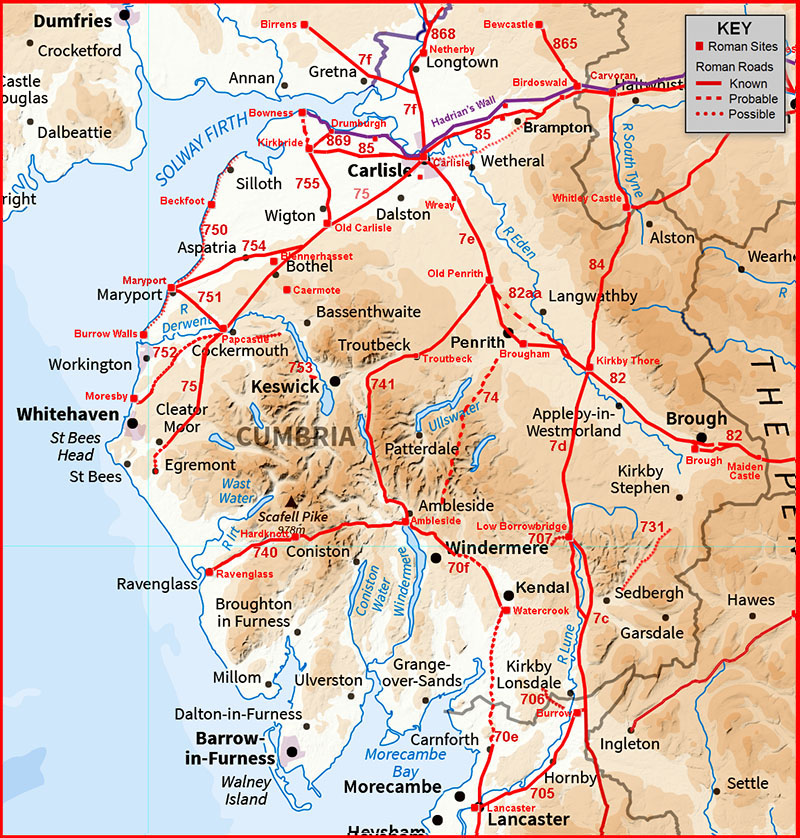
IntroductionAlthough there are still some big gaps in our knowledge of Cumbria's Roman roads the last few years have seen great strides in completing the picture. The reason for this has been the advent of Lidar. Lidar data is collected from an aeroplane scanning the ground with laser beams of light which measures the height of the ground to incredible precision. In this country its primary purpose has been for flood defence but it has opened a fantastic window of discovery for archaeology. Below are links to each of the roads shown above. The content is evolving and if you spot something wrong or have some local knowledge please do get in touch (see email at the bottom).
The RoadsFor all the known routes (in numerical order - well 7s before 8s). Please choose the appropriate page(s):- > Burrow (Lancashire) to Low Borrowbridge (M7c)- this route is largely known except for around Sedbergh and Lidar has provided some clues to its course there. > Middleton to Low Borrowbridge (M7ca) - NEW There was an alternative route from Middleton to Low Borrowbridge on the Lune's west bank! > Low Borrowbridge to Kirkby Thore (M7d) - Hugh Toller discovered the destination for this road was Kirkby Thore not Brougham. One of the first discoveries using Lidar. > Brougham to Old Penrith to Carlisle (M7e) - this road was recently exposed at Penrith plus a new fort was spotted at Wreay. > Carlisle to Birrens (M7f) - route of the road to Birrens confirmed from Roost Ford across the MOD depot. See M868 for route to Netherby.
> Watercrook to Ambleside (M70f) - some progress at long last! > High Street (M74) - VIDEO Flyover available. The most famous road in the county but is it really Roman? Make your own mind up. > Carlisle to Papcastle (M75) - route via Old Carlisle and Lidar has now filled in the gaps at Thursby and Bothel. Also a link road to Blennerhasset. > Papcastle to Ravenglass (M75) - 2021 Update - route from Papcastle to Ullock located. > Low Borrowbridge to Watercrook (M707) - included for completeness but not much evidence to show for this road. > Sedbergh to Kirkby Stephen (M731) - a puzzle but what is known does have Roman characteristics. > Ambleside to Ravenglass (M740) - several of the missing pieces have been filled in and the route down Eskdale completed. > Ambleside to Old Penrith (M741) - a major new south-to-north route through the very centre of the county.
> The Coastal Road (M750) - not a lot of evidence but some good images! > Papcastle to Maryport (M751) - one of the simplest most direct roads in the County. > Papcastle to Moresby (M752) - a route suggested by Bellhouse is somewhat lacking in evidence but there is an easier alternative. > Papcastle to Keswick (M753) - various suggestions for this road and we look at 3 options. > Old Carlisle to Maryport (M754) - route determined completing the work begun by Bellhouse. > Old Carlisle to Kirkbride(M755) - complete new road discovered. It probably continues on to Bowness-on-Solway.
> Maiden Castle to Brough (M82) - puzzling section that has at last been resolved by new Lidar - there are 3 routes! > Brough to Kirkby Thore (M82) - the connection from Brough fort to the known lengths represented by the A66 has now been made. > Kirkby Thore to Brougham (M82) - crossing the Eden turned out to be a Roman spaghetti junction! > Kirkby Thore to Old Penrith (M82aa) - How the Roman made a crossroads with only 3 roads. > Maiden Way Part 1: Kirkby Thore to Whitley Castle (M84) - Probably the highest Roman road in England. > Maiden Way Part 2: Whitley Castle to Carvoran (M84) - The less spectacular section along the South Tyne Valley in Northumberland
> The Stanegate (M85) - Cumbria - Throp to Carlisle. Major road with a missing section. Finding this has created another puzzle in its place! > The Stanegate (M85) - Northumberland - Corbridge to Throp - at last the road is located at Corbridge. > The Western Stanegate (M85) - 2021 Update : complete route located so yes there was a Western Stanegate!. > The Military Way (M86) - just a few traces here and there but some good images. > Birdoswald to Bewcastle (M865) - a simple road that turned out to have a start no one expected - the Romans didn't want to get their feet wet! > Sandysike to Netherby and into Scotland (M868) - north from Carlisle and Netherby is not a cul-de-sac after all! It is on "new" routes to Scotland. > Drumburgh to Kirkbride (M869) - Bellhouse's road updated and extended right to Drumburgh fort.
> Possible Roads - Lancaster to Ravenglass, Moresby to Ravenglass, Ambleside to Troutbeck via Kirkstone Pass and Birdoswald to Nether Denton (NEW)
AcknowledgementsIt has been a huge task to document each of our Roman roads. However, it could not have been done without the help of many colleagues. These include Hugh Toller, Bryn Gethin, Mike Haken, Pete Wilson, Mark Brennand, John Poulter, Bill Shannon and Mark Richards. Needless to say any errors are mine (David Ratledge) alone. Raw (ascii) Lidar is copyright The Environment Agency. The processed Lidar data shown here is copyright David Ratledge. Thanks are due to Mike Aerts for developing his bespoke "magic" Lidar software that turns numbers into pictures. Mapping used is generally OS Opendata supplemented by Bing Mapping and Aerial Photography for a few selected areas.
ReferencesThese are references are applicable generally. Specific ones are located with individual roads. Roman Roads in Britain, I.D. Margary, 1973. Always the starting point even though it is now long out of date. The "Margary" road numbers are from this book. CWAAS Transactions. Comprehensive in depth source of published data for Cumbria. All but the latest volumes are now available on line. Roads and Trackways of the Lake District, Paul Hindle, 1984. A great general overview of Cumbria's roads through time. Hadrian's Wall from the Air, GDB Jones & DJ Wooliscroft, 2001. The coverage is broader than the title would suggest. Romans and Britons in North-West England, David Shotter, 2004. Overview of the conquest and occupation. Handbook to Hadrian's Wall, David Breeze, 2006. Must have book. The Roman Army in Northern England, P. Bidwell & N. Hodgson, 2009. Details of all the northern forts not included in Hadrian's Wall Handbook. Roman Roads & Walls in Northern Britain, John Poulter, 2010. Suggestions on how the roads were planned and set-out. The Secret History of the Roman Roads of Britain, M.C. Bishop, 2014. Excellent introduction and even answers the question how long would it take to build a road. Cumbria's Roman Roads, A LiDAR Update, David Ratledge, CWAAS Transactions, 2017. Cumbria's Roman Roads, A Second LiDAR Update, David Ratledge, CWAAS Transactions, 2020. A Second Roman Road from Middleton to Low Borrowbridge, David Ratledge, CWAAS News Autumn 2020 (No.95). The Stainmore Roman Road: Maiden Castle to Brough, Margary 82, David Ratledge, CWAAS News Summer 2022, (No.100),
Contact David Ratledge regarding the Cumbrian web pages: |
|
|
|
|
Last update: October 2022 |
© David Ratledge |