 |
Essex's Roman RoadsA Lidar Re-appraisalThis is the first version of Essex's Roman Roads web pages and has been compiled by David Ratledge. As such I will probably have made several errors and missed some important information - please let me know. I will not be offended! With your help we can make this the best available resource for Essex. The road numbering system is based on that devised by Ivan Margary over 60 years ago. Although long out of date it is still the best we have. However, some roads in Essex were unknown to Margary and therefore have no numbers. Lidar, both 2D and 3D virtual reality models have been used extensively in appraising the alignment of the roads. This technique has proved an extremely efficient way of detecting linear feature such as Roman roads. Imagery derived from this data is often able to show clearly the surviving remains of the road agger, terraces, side ditches and cuttings, often where they cannot be identified easily on the ground through traditional fieldwork. In addition other online and written sources have been consulted.
|
 |
Road numbers are those allocated by Ivan Margary |
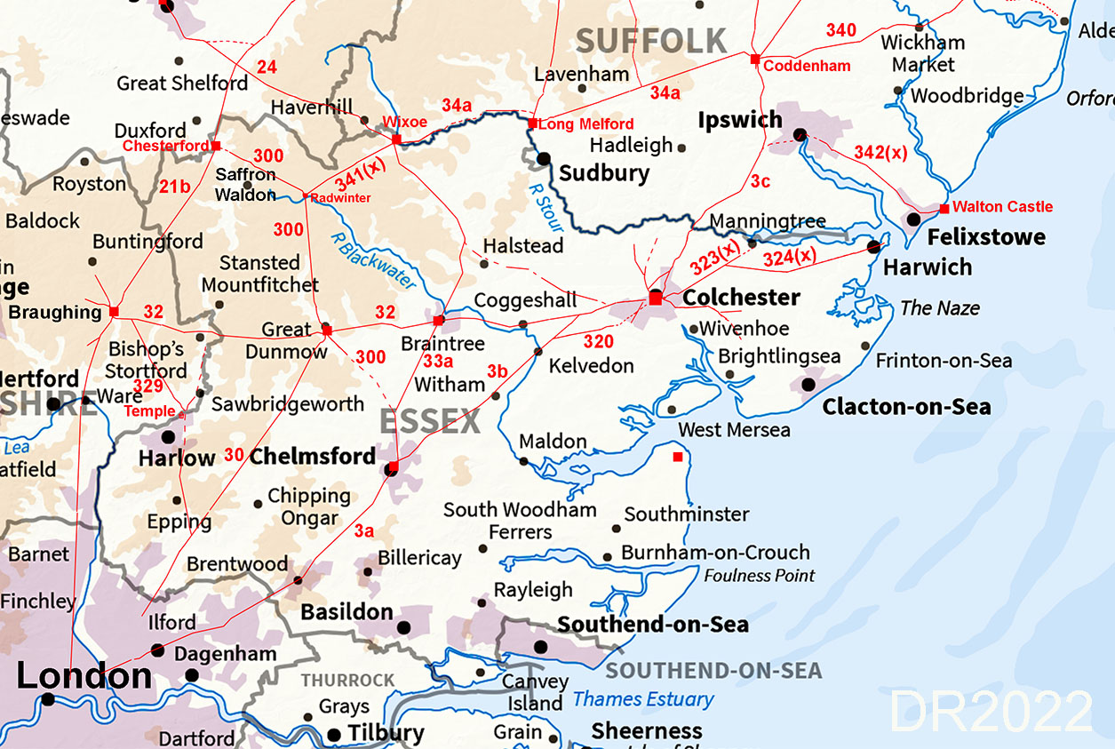
IntroductionAlthough our route map, on the face of it, looks very familiar some "new" roads have been added plus several gaps have been filled in together with refinements here and there. The most important road hub by far is of course Colchester. Not all Colchester's road puzzles have been solved - the roads to the south-east and north are incomplete.. The south-east of the County is still a puzzle - perhaps more work is required here. It should also be pointed out the Romans would have exploited river and sea transport so the coastal area of the county would have also been served by boat. Essex's Roman RoadsFor all the known routes in detail choose the appropriate page:-Coddenham - Colchester - Chelmsford - London, Margary 3 Coddenham - Colchester Just a few corrections to this largely known route to the important city of Camulodunum. A likely second route into Colchester too. Colchester - Chelmsford Shares the first section with the Roman Road (Stane Street) to Braintree Chelmsford - London Margary's Great Road. Mostly well determined but a new section suggested at Margaretting. Stane Street - Colchester to Braughing, Margary 32 Colchester to Braintree Possibly two routes from the famous Balkerne Gate then very direct to the Roman settlement at Braintree Braintree to Great Dunmow Stane Street continues on west of Braintree through Rayne to the Roman Settlement at Great Dunmow Great Dunmow to Braughing, This final section of Stane Street is half in Essex and half in Herfordshire. Other Roman Roads around Colchester Colchester to Gosbecks - Kelvedon, Margary 320 This road looks obvious but evidence proving its existence is somewhat lacking. Colchester to Lawford & Harwich Possibly a fort at Lawford plus this road had a branch off it to, almost certainly, Harwich. Colchester to South-East Puzzling road(s) towards the coast but the Lidar evidence dries up. Colchester to the North From the north gate one, probably two roads head northwards but to where? Colchester to Braintree Corner A logical route but evidence is poor so only classed as "possible." Roman Roads around Harlow Hobbs Cross to Harlow Often suggested and now we have the evidence and the route. Harlow to Stane Street for Braughing, Margary 329 Margary recorded sections of this road and and we fill in the gaps and connect it to Harlow Harlow to Bishop's Storford A logical road with not a lot of evidence Great Chesterford - Great Dunmow - Chelmsford(?), Margary 300 Great Chesterford to Radwinter The route at Chesterford is a puzzle but from there on then it is pretty clear. Radwinter to Great Dunmow North to south road and traceable all the way Great Dunmow to Little Waltham (for Chelmsford) Almost certainly a Roman road but has several missing sections Other Roman Roads Wixoe to Braintree Newly Discovered Road Wixoe to Radwinter A suspected road now fully traced. Great Chesterford to Braughing, Margary 21, Very prominent in the Lidar data</p> Braintree to Chelmsford, Margary 33a Two main alignment with a turn at Little Waltham Great Dunmow to London, Margary 30 Virtually one long alignment heading for London.
AcknowledgementsTop of the list for thanks must go Colchester Archaeology Group and their Roman Roads Group led by Geoff Lunn. Thanks also. to Colchester Historic Environment Record (HER) and their online database and mapping. Local books I found particularly useful were Boudica to Raedwald by John Fairclough and Prehistoric & Roman Essex by James Kemble - see references below. Thanks are also due to Mike Aerts for developing his bespoke "MAGIC" Lidar software that turns numbers into 3D virtual reality models. Raw (ascii) Lidar is copyright DEFRA. The processed Lidar data shown here is copyright David Ratledge. Having said that, you are welcome to use any of the Lidar images providing a source reference is given. Mapping used is generally Ordnance Survey Opendata supplemented by Bing Mapping and Aerial Photography for selected areas. Google imagery has also been utilised.
References:Below are general references. Specific ones pertaining to a particular road are included on the appropriate web page.
Roman Roads in Britain, Codrington, 1903/1918. (Bill Thayer's online version). Roman Roads in Britain, I.D. Margary, 1957. Way out of date but still the first "go to" source book. The Margary road numbers used here are from this book. A Context for Sitomagus Romano-British settlement in the Suffolk mid-coastal area, Robert Steerwood, Suffolk Institute of A & H, Vol XL, 2003. It wasn't on the coast after all. Prehistoric & Roman Essex, James Kemble, 2009. Despite the title it includes south Suffolk as well. Boudica to Raedwald, East Anglia's Relations with Rome, John Fairclough, 2010. Includes a chapter and appendix on Suffolk's Roman roads.. Colchester Archaeology Grooup (CAG), publishes reports, updates and other information Bulletins.from 1958. Has active Roman Roads group. Colchester Heritage Explorer Includes general articles plus Colchester's HER Records available via online GIS (mapping)
Contacts:To contact David Ratledge regarding the Suffolk web pages, please email me.
|
|

|
|
|
Last update: July 2022 |
© David Ratledge |