 |
Hertfordshire's Roman RoadsA Lidar Re-appraisalSt Albans was the most important Roman town (city) in the county and was clearly a focus for Roman roads with at least six converging there. By the fourth century, Verulamium was the third-largest city of Roman Britain after London and Cirencester. Elsewhere in the county, then the settlement at Braughing was also at the centre of six Roman roads. Baldock was the other road hub with three roads plus the pre-Roman Icknield Way all heading ftowards it. Lidar, both 2D and 3D virtual reality models have been used extensively in appraising the alignment of the roads. This technique has proved an extremely efficient way of detecting linear feature such as Roman roads. Imagery derived from this data is often able to show clearly the surviving remains of the road agger, terraces, side ditches and cuttings, often where they cannot be identified easily on the ground through traditional fieldwork.
|
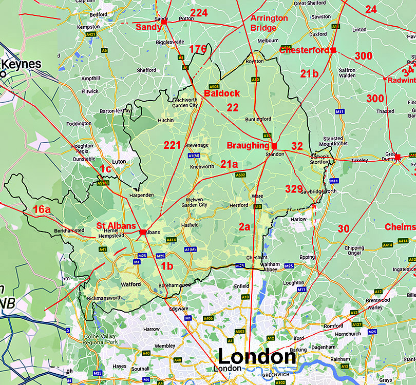 |
Road numbers are those allocated by Ivan Margary |
IntroductionThis was an area where the Viatores Group (see references) proposed many Roman roads. However, the majority of these do not pass modern scrutiny and have not been included here. No completely "new" roads have been spotted but several gaps have been filled and tweaks to the alignments here and there. Probably the most significant is the route of the road to Silchester which had long been a puzzle. Hertfordshire's Roman RoadsFor all the known routes in detail choose the appropriate page:-The Roman Roads around St Albans St Albans to SIlchester RR163 For a long time a puzzle as to the route the Romans took. At last we have the answer. Akeman Street, RR16a, Two options for the beginning of this route and then straight forward. Watling Street North, RR1c The Roman's main route north. St Albans to Baldock, RR221 A road of two halves. The northern section is well known but the southern section was lost. St Albans to Braughing RR21a St Alban's connection to Ermine Street for the north and Stane Street for Colchester. Watling Street South, RR1b St Albans to London. Is the traditional route at Elstree correct? The Roman Roads around Braughing Braughing to Baldock, RR22 A well-established Roman road but with the first section missing - until now. Ermine Street North, RR2b A Roman road still much in use today. Braughing to Great Chesterford, RR21b Described in the reverse direction. Braughing's link to Cambridge and the Fens. Braughing to Great Dunmow, Stane Street, RR32 Actually described in the reverse direction. Braughing's link to Colchester Braughing to Harlow, RR329 Suggested by Margary and we are now able to complete the route. Ermine Street South, RR2a Very direct route heading for London. One probable slight adjustment to the route Other Roman Road Arrington Bridge to Stotfold, RR176 Recently dicovered road starting in Cambridgeshire. Possible Roman Roads Possible and Rejected Roman Roads Explanations as to why some suggested roads did not make it to my map.
AcknowledgementsThanks are due to Mike Aerts for developing his bespoke "MAGIC" Lidar software that turns numbers into 3D virtual reality models Raw (ascii) Lidar is copyright DEFRA/The Environment Agency. The processed Lidar data shown here is copyright David Ratledge. Having said that, you are welcome to use any of the Lidar images providing a source reference is given. Mapping used is generally Ordnance Survey Opendata supplemented by Bing Mapping and Aerial Photography for selected areas. Google imagery has also been utilised.
References:Below are general references. Specific ones pertaining to a particular road are included on the appropriate web page.
Roman Roads in Britain, Codrington, 1903/1918. (Bill Thayer's online version). Roman Roads in Britain, I.D. Margary, 1957. Way out of date but still the first "go to" source book. The Margary road numbers used here are from this book. Roman Roads in the South-East Midlands, The Viatores, 1964. Roman Hertfordshire, Rosalind Niblett, 1995. The problem with Roman roads, Dr Kris Lockyear, St Albans and Hertfordshire Architectural and Archaeological Society, 2022. A Hertfordshire Triangle, David Ratledge, the triangle of roads between Verulamium , Baldock and Braughing, RRRA Newsletter No.29, Summer 2024. Hertfordshire HER Excellent online mapping of the county's archaeological sites.
RRRA = Roman Roads Research Association Contact:To contact David Ratledge regarding the Norfolk web pages, please email me.
|
|

|
|
|
Last update: April 2025 |
© David Ratledge |