
|
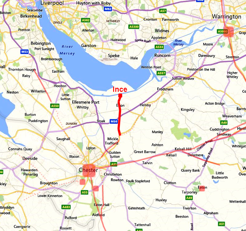
The Roman Road from Bridge Trafford to Ince FortletMargary Number: 701aaDistance: 3.6 milesThe small fortlet at Ince was not identified until 1994, however in his 1886 publication Roman Cheshire, the antiquarian WT Watkin suspected the possibility of a Roman Road branching off to the north west from the Chester to Warrington road (RR701) at Bridge Trafford. When Margary published The Roman Roads of Britain in 1985 the fort was still undiscovered and no new evidence supporting Watkins' speculation had emerged so consequently it was not identified or numbered. The fortlet is thought to have been constructed in the early years of the occupation to monitor marine traffic along the coast to and from Wilderspool (Warrington) and possibly to guard against incursions from the north. It must be noted that there is very little positive evidence for the course of this road. |
Historic Counties: Cheshire Current Counties: Cheshire HER: Cheshire
|
|
|
|
|
|
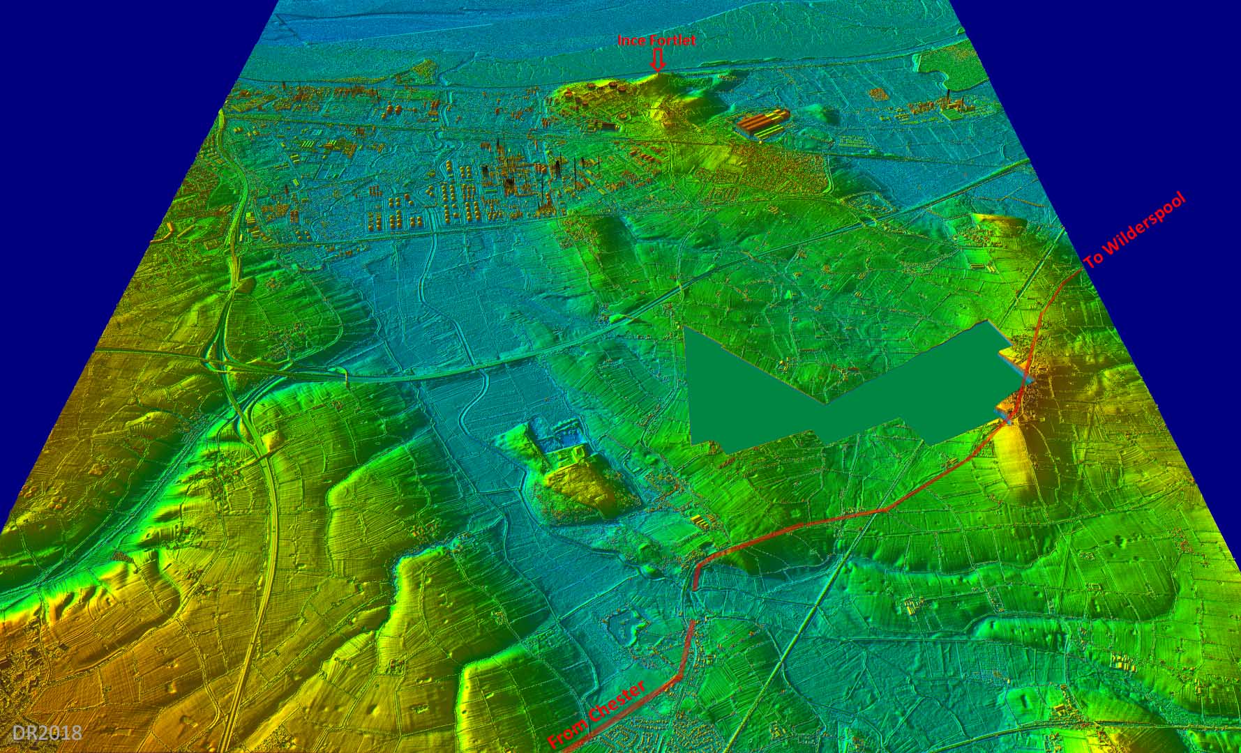
Oblique 3D Lidar Image - Ince Peninsular What a strategic spot the Ince forlet occupies! The colour scheme is indicative of the probable coastline/sea marsh in Roman times and Ince commands, what must have been in those days, a peninsular. Its connecting road would have branched off the Wilderspool road after the River Gowy was crossed, almost certainly by a bridge. The modern Cryers Lane has several straight stretches and probably overlies much of the Roman road. |
Click for larger view |
 |
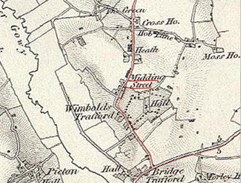
Route Map 1 - Bridge Trafford to Cross House Farm The bridge at Bridge Trafford is thought to be built on the site of an original ford on the River Gowy. It is believed to be the crossing point of Margary's route 701 from Chester to Wilderspool near Warrington. It is from the east side of the bridge that Watkin suspected there was a branch off to the north "leading to the Ince area" but his only documentary clue was from the 1837 map where a location known a Midding Street was recorded but the location disappeared from later map issues |
Click for larger view |
 |
Midding Street SJ449725 Midding Street probably refers to the property shown just to left of lane. By 1873 it had disappeared as it does not appear on the OS First Edition map. However, it is probably as good a clue as we are going to get on this road. The name "street" often (but not always) implies the presence of a Roman road. A minor excavation in a field near Manor Farm (somewhere near Heath on the this map) carried out by Dutton failed to locate evidence for the road. He was however looking for a straight line from the Gowy bridge. |
Click for larger view |
 |
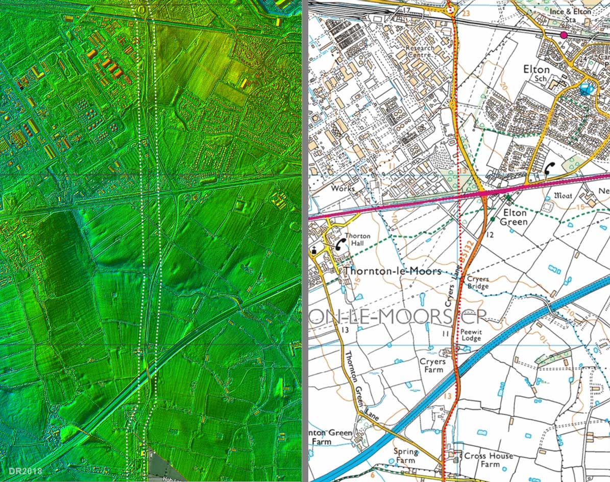
Route Map 2 - Cross House Farm to Elton From the cross roads south of Cross House Farm the Roman route is probably represented by Cryers Lane (B5132) but the Roman alignment would have been somewhat straighter. Cryers bridge is probably on the line (see the Pavement hey evidence below) but perhaps the Roman line was west of the modern road near Elton Green. There is the false clue of an underground pipeline here and it could well have destroyed some of the Roman road.
|
Click for larger view |
 |
Cryers Farm - Pavement Hey Fields Some support is for the alignment following the straight part of Cryers Lane is found in the name of three fields directly opposite Cryers Farm house. All three were called "Pavement Hey" on the 1847 Tithe Map. The use of the word "pavement" in old field names is often associated with ancient routes, in this case on their western boundary. If these are a valid clue then the road must have passed through these fields or at least along their edge. The latter would seem the most likely taking the Roman line via Cryers Bridge Another Tithe Map field name on the other side of the road, to the north of Cryers Farm was Holdfords Field. Perhaps another clue to an old road passing this way. However, it is likely this would refer to a ford of much later date than Roman period where almost certainly a bridge would have been constructed.
|
Click for larger view |
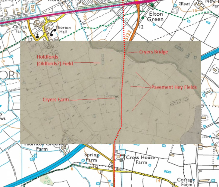 |
Cryers Bridge The road crossing Cryers Bridge does have Roman characteristics. It is on a built up agger, it has side ditches and is heading for Ince. The last Pavement Hey field in on the right before the bridge. |
Click for larger view |
 |
OS First Edition Map - Elton There is one clue that the Roman alignment probably straight-lined passing Elton. A short length of hedge doglegs onto the probable line. |
Click for larger view |
 |
Route Map 3 - Elton to Ince Fortlet Instead of going via Ince, it is likely that at SJ449762 the Roman Road left Pool Lane to go through the west side of the park opposite St James the Great and eventually meet Kinseys Lane which it followed up the incline to the fort. This is more logical and less steep approach to the hillock on which Ince Fortlet is located. See below for a more detailed view of the final approach. |
Click for larger view |
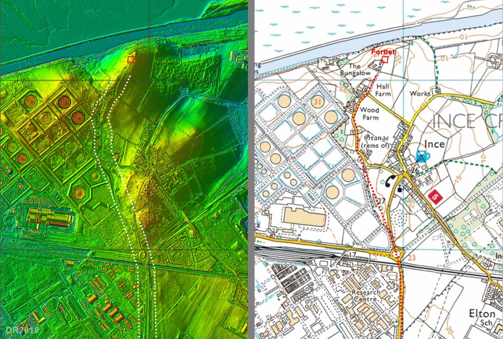 |
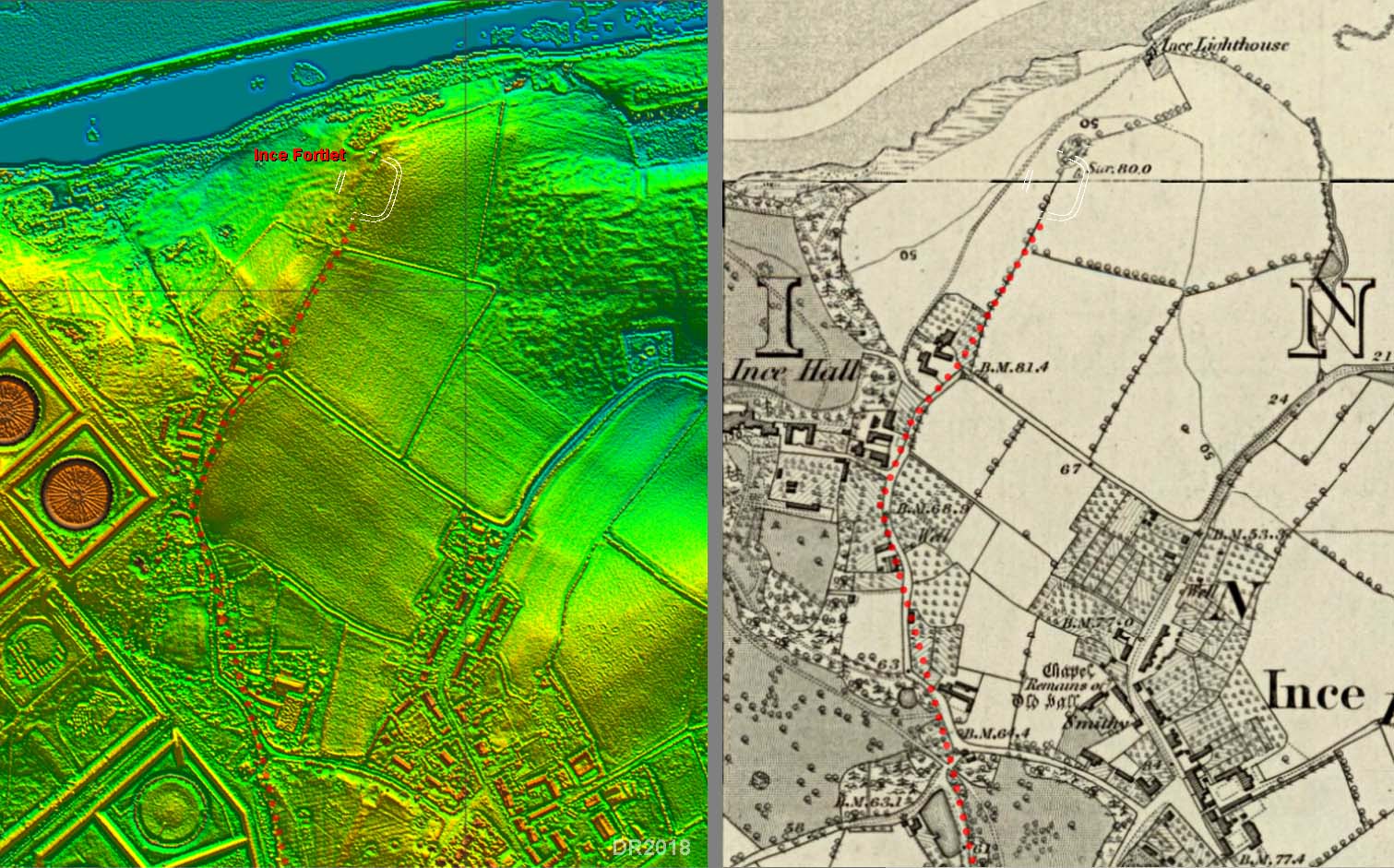
Lidar Image & OS First Edition Map - Roman Fortlet at Ince Scheduled Monument No 101472 Cheshire Past Vol 4 has the following entry. "Aerial photography in June 1992 revealed a previously-unknown Roman fortlet at Ince near Stanlow. The site showed up as a crop mark in the form of a double ditched enclosure with an entrance on the southern side. Computer plotting of the aerial photographs shows that it measures externally about 72m north-south by 62m east-west, giving an internal area of about 0.35ha or 0.9 acres" Those crop marks have been transferred to both the lidar image and the map. |
Click for larger view |
 |
|
|
|
Last update: August 2018 |
© David Ratledge & Neil Buckley |